
 Feeds & Data
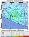
Magnitude 6.1 - GUERRERO, MEXICO
2006 August 11 14:30:39 UTC
Earthquake Details
| Magnitude | 6.1 |
|---|---|
| Date-Time |
= Coordinated Universal Time = local time at epicenter |
| Location | 18.492°N, 100.935°W |
| Depth | 60.1 km (37.3 miles) set by location program |
| Region | GUERRERO, MEXICO |
| Distances | 80 km (50 miles) WNW of Arcelia, Guerrero, Mexico 115 km (70 miles) SSW of Zitacuaro, Michoacan, Mexico 120 km (75 miles) NNE of Zihuatanejo, Guerrero, Mexico 210 km (130 miles) WSW of MEXICO CITY, D.F., Mexico |
| Location Uncertainty | horizontal +/- 4.1 km (2.5 miles); depth fixed by location program |
| Parameters | Nst=243, Nph=243, Dmin=>999 km, Rmss=0.89 sec, Gp= 47°, M-type=teleseismic moment magnitude (Mw), Version=R |
| Source | USGS NEIC (WDCS-D) |
| Event ID | usrgaw |
- This event has been reviewed by a seismologist.
Did you feel it?
Report shaking and damage at your location. You can also view a map displaying accumulated data from your report and others.
Earthquake Summary


Felt Reports
Felt (III) at Mexico City. Also felt at Acatlan, Arcelia, Chiautla, Cuautla, Cuernavaca, El Grullo, Ixtapa, Lerma, Morelia, Patzcuaro, Puebla, Puruandiro, Queretaro, Tenancingo, Toluca, Villa Guerrero, Zacapu, Zacualpan and Zihuatanejo.
Earthquake Maps
Earthquake Location
Location Maps

Did You Feel It?
Tell Us
ShakeMap

Historical Seismicity

Seismic Hazard Map

EQ Density Map

Google Map

 Historic Moment Tensor Solutions
- Preliminary Earthquake Report
- U.S. Geological Survey, National Earthquake Information Center
World Data Center for Seismology, Denver
