
 Feeds & Data
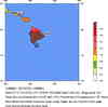
Magnitude 5.2 - HAWAII REGION, HAWAII
2005 July 17 19:15:03 UTC
Earthquake Details
| Magnitude | 5.2 |
|---|---|
| Date-Time |
|
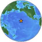
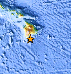
| Location | 18.810°N, 155.446°W |
| Depth | 28.4 km (17.6 miles) |
| Region | HAWAII REGION, HAWAII |
| Distances |
|
| Location Uncertainty | horizontal +/- 1.2 km (0.7 miles); depth +/- 1.9 km (1.2 miles) |
| Parameters | Nph=056, Dmin=30.4 km, Rmss=0.11 sec, Gp=270°, M-type=duration magnitude (Md), Version=4 |
| Source | |
| Event ID | hv05440164 |
- This event has been reviewed by a seismologist.
- Did you feel it? Report shaking and damage at your location. You can also view a map displaying accumulated data from your report and others.
Earthquake Summary
Earthquake Information for HAWAII
Tsunami Information
- West Coast & Alaska Tsunami Warning Center
- Pacific Tsunami Warning Center
- Recent Tsunamis
The earthquake locations and magnitudes cited in these bulletins are very preliminary, and may disagree with the more accurate USGS locations and magnitudes computed using more extensive data sets.
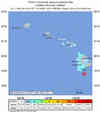
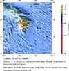
Earthquake Maps

Scientific & Technical Information
 Historic Moment Tensor Solutions
- Preliminary Earthquake Report
- U.S. Geological Survey, Hawaiian Volcano Observatory
Hawaii National Park, Hawaii
