
 Feeds & Data
Magnitude 6.8 - CAYMAN ISLANDS REGION
2004 December 14 23:20:13 UTC
Earthquake Details
| Magnitude | 6.8 |
|---|---|
| Date-Time |
= Coordinated Universal Time = local time at epicenter |
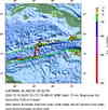
| Location | 18.958°N, 81.409°W |
| Depth | 10 km (6.2 miles) set by location program |
| Region | CAYMAN ISLANDS REGION |
| Distances |
35 km (20 miles) SSE of GEORGE TOWN, Cayman Islands 325 km (205 miles) ENE of Swan Island 360 km (225 miles) SSW of Cienfuegos, Cuba 760 km (470 miles) S of Miami, Florida |
| Location Uncertainty | horizontal +/- 3.4 km; depth fixed by location program |
| Parameters | Nst=584, Nph=584, Dmin=734.5 km, Rmss=0.99 sec, Gp= 21.8°, |
| Source | USGS NEIC (WDCS-D) |
| Event ID | ussadb |
- This event has been reviewed by a seismologist.
Did you feel it?
Report shaking and damage at your location. You can also view a map displaying accumulated data from your report and others.
Earthquake Maps

Earthquake Location

Location Maps

ShakeMap
Historical Seismicity

Seismic Hazard Map

EQ Density Map

Google Map
Did you feel it?
Report shaking and damage at your location. You can also view a map displaying accumulated data from your report and others.
 Historic Moment Tensor Solutions
- Preliminary Earthquake Report
- U.S. Geological Survey, National Earthquake Information Center
World Data Center for Seismology, Denver
