
 Feeds & Data
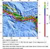
Magnitude 6.7 - SOLOMON ISLANDS
2004 November 11 17:34:53 UTC


Earthquake Details
| Magnitude | 6.7 (Strong) |
|---|---|
| Date-Time |
= Coordinated Universal Time = local time at epicenter |
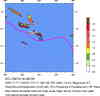
| Location | 11.134°S, 162.193°E |
| Depth | 21.9 km (13.6 miles) |
| Region | SOLOMON ISLANDS |
| Distances | 80 km (50 miles) SSE of Kira Kira, San Cristobal, Solomon Isl. 305 km (190 miles) SE of HONIARA, Guadalcanal, Solomon Islands 310 km (195 miles) SSE of Auki, Malaita, Solomon Islands 2055 km (1270 miles) NNE of BRISBANE, Queensland, Australia |
| Location Uncertainty | horizontal +/- 8.3 km (5.2 miles); depth +/- 20.9 km (13.0 miles) |
| Parameters | Nst=144, Nph=144, Dmin=>999 km, Rmss=0.99 sec, Gp= 50°, M-type=teleseismic moment magnitude (Mw), Version=R |
| Source | USGS NEIC (WDCS-D) |
| Event ID | usqsbr |
- This event has been reviewed by a seismologist.
Did you feel it?
Report shaking and damage at your location. You can also view a map displaying accumulated data from your report and others.


- Preliminary Earthquake Report
- U.S. Geological Survey, National Earthquake Information Center
World Data Center for Seismology, Denver
