
 Feeds & Data
Magnitude 7.0 - NEAR THE COAST OF NICARAGUA
2004 October 9 21:26:53 UTC
Earthquake Details
| Magnitude | 7.0 |
|---|---|
| Date-Time |
= Coordinated Universal Time = local time at epicenter |
| Location | 11.422°N, 86.665°W |
| Depth | 35 km (21.7 miles) set by location program |
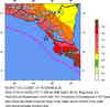
| Region | NEAR THE COAST OF NICARAGUA |
| Distances |
85 km (50 miles) SSW of MANAGUA, Nicaragua 90 km (55 miles) W of Rivas, Nicaragua 95 km (60 miles) SW of Granada, Nicaragua 1605 km (1000 miles) ESE of MEXICO CITY, D.F., Mexico |
| Location Uncertainty | horizontal +/- 5.8 km; depth fixed by location program |
| Parameters | Nst=379, Nph=379, Dmin=224.5 km, Rmss=1.30 sec, Gp= 33.6°, M-type=teleseismic moment magnitude (Mw) |
| Source | USGS NEIC (WDCS-D) |
| Event ID | uspjcz |
- This event has been reviewed by a seismologist.
Did you feel it?
Report shaking and damage at your location. You can also view a map displaying accumulated data from your report and others.
Earthquake Maps

Earthquake Location

Location Maps

Historical Seismicity
Seismic Hazard Map

Google Map
Did you feel it?
Report shaking and damage at your location. You can also view a map displaying accumulated data from your report and others.
 Historic Moment Tensor Solutions
- Preliminary Earthquake Report
- U.S. Geological Survey, National Earthquake Information Center
World Data Center for Seismology, Denver
