|
Arizona | California | Colorado | Idaho | Montana | New Mexico | Oregon | Utah
Arizona | | | | Agua Fria National Monument
The Agua Fria National Monument contains one of the most significant systems of late prehistoric sites in the American Southwest. Between A.D. 1250 and 1450, the region’s pueblo communities were populated by as many as several thousand people. Agua Fria's ancient ruins offer insights into the lives of those who long ago inhabited this part of the desert southwest. Established by presidential proclamation in 2000, the Monument comprises approximately 71,000 acres containing at least 450 prehistoric sites.
| | | Grand Canyon-Parashant National Monument
The Grand Canyon-Parashant National Monument is a vast, biologically diverse landscape encompassing an array of scientific and historic objects. The BLM and the National Park Service jointly manage the Monument, which was established by presidential proclamation in 2000. Valuable geological resources are located within the Monument boundaries, including relatively undeformed and unobscured Paleozoic and Mesozoic sedimentary rock layers and abundant fossils, which offer a clear view of the geologic history of the Colorado Plateau. The Monument also contains outstanding biological resources including giant Mojave yucca, trophy-quality mule deer, California condor, desert tortoise, and southwestern willow flycatcher.
| | | Ironwood Forest National Monument
The Ironwood Forest National Monument offers quintessential views of the Sonoran Desert’s ancient legume and cactus forests. The Monument, established by presidential proclamation in June 2000, encompass nearly 130,000 acres, including some of the Sonoran Desert's highest density ironwood trees stands. Ironwood trees provide, among other things, roosting sites for hawks and owls, forage for desert bighorn sheep, protection for saguaro against freezing, burrows for tortoises, flowers for native bees, dense canopy for nesting of white-winged doves and other birds, and protection against the sun for night blooming cereus.
| | | Sonoran Desert National Monument
This Sonoran Desert National Monument is a magnificent example of untrammeled desert landscape, presenting an extraordinary array of biological, scientific, and historic resources within a functioning desert ecosystem. Encompassing nearly 500,000 acres, the Monument was established in January 2001 by presidential proclamation. The Monument’s diverse plant communities, including striking saguaro cactus forests, support a wide variety of wildlife, such as desert bighorn sheep, mountain lions, Sonoran desert tortoise, and over 200 species of birds.
| | | Vermilion Cliffs National Monument
Despite its arid climate and rugged isolation, Vermilion Cliffs National Monument is home to diverse plant and animal species as well as a long and rich human history. The Vermilion Cliffs rise 3,000 feet above the Paria Plateau to form a spectacular sandstone-capped escarpment underlain by multicolored, actively eroding layers of shale and sandstone. The Monument, established by presidential proclamation in 2000, encompasses nearly 300,000 acres. At least twenty species of raptors have been documented in the Monument, as well as a variety of reptiles and amphibians. California Condors have been reintroduced as part of a broader effort to recover this highly endangered species.
| California | | | | California Coastal National Monument
The California Coastal National Monument is a biological and scenic treasure. Its thousands of islands, rocks, exposed reefs, and pinnacles are part of the near shore ocean zone, which begins just off shore and ends at the boundary between the continental shelf and continental slope. The Monument, established by presidential proclamation in 2000, provides feeding and nesting habitat for an estimated 200,000 breeding seabirds, as well as forage and breeding habitat for marine mammals including the southern sea otters and California sea lions .
| | | Carrizo Plain National Monument
Full of natural splendor and rich in human history, the grasslands and stark ridges of the Carrizo Plain National Monument contain exceptional objects of scientific and historic interest. Encompassing more than 200,000 acres, the monument was established presidential proclamation in 2001. The Monument is home to the largest concentration of endangered species in all of California, in part because the remote 45-mile-long plain is an ecological "island." It is California's single largest remaining remnant of native grassland that was once abundant in the southern San Joaquin Valley .
| | | Santa Rosa and San Jacinto Mountians National Monument
Santa Rosa and San Jacinto Mountains of southern California contain nationally significant biological, cultural, recreational, geological, educational and scientific resources. The vistas, wildlife, land forms, and natural and cultural resources of these mountains provide a counterpoint to the highly urbanized areas of the nearby Coachella Valley . The Santa Rosa and San Jacinto Mountains National Monument Act established the unit in October 2000.
| Colorado | | | | Canyons of the Ancients National Monument
Containing the highest known density of archaeological sites in the nation, Canyons of the Ancients National Monument holds evidence of cultures and traditions spanning thousands of years. The Monument’s complex landscape and remarkable cultural resources offer unparalleled opportunities to study and experience how cultures in the American Southwest lived and adapted over time. A presidential proclamation established the Monument in 2000.
| Idaho | | | | Craters of the Moon National Monument
Craters of the Moon National Monument was established on
May 2, 1924, to protect the unusual landscape of the Craters of the Moon lava field. The scientific value of the monument lies in the great diversity of volcanic features preserved within a relatively small area. A presidential proclamation in 2000 expanded the Monument to its current size of approximately 661,000 acres, which are managed jointly by the BLM and the National Park Service. The monument’s central focus is the Great Rift, a 62-mile long crack in the earth's crust. The Great Rift is the source of a remarkably preserved volcanic landscape with an array of exceptional features. Craters, cinder cones, lava tubes, deep cracks, and vast lava fields form a strangely beautiful volcanic sea on central Idaho's Snake River Plain.
| Montana | | | | Pompeys Pillar National Monument
Pompeys Pillar is a massive sandstone outcrop on the banks of the Yellowstone River; it has been a celebrated landmark and outstanding observation point for the more than 11,000 years that humans have occupied the area. The Monument’s most notable visitor, Captain William Clark of the Lewis and Clark Expedition, stopped at Pompeys Pillar on July 25, 1806, while returning from the Pacific coast. The 51-acre site was declared a Monument by presidential proclamation in 2001.
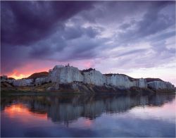
| | | Upper Missouri River National Monument
The dramatic cliffs along the 149-mile stretch of river running through the Missouri River Breaks National Monument remain virtually unchanged since Lewis & Clark traveled through the area 200 years ago. A presidential proclamation established the 370,000-acre monument in 2001. Glaciers, volcanic activity, and erosion folded, faulted, uplifted, and sculpted the landscape into the majestic form it takes today. The Lewis & Clark National Historic Trail and the Nez Perce National Historic Trail run through the Monument.
| New Mexico | | | | Kasha-Katuwe Tent Rocks National Monument
Located in north-central New Mexico , the Kasha-Katuwe Tent Rocks National Monument is an outdoor laboratory that offers an opportunity to observe geologic processes as well as cultural and biological objects of interest. Cone-shaped tent rock formations are the products of explosive volcanic eruptions that occurred between 6 and 7 million years ago. The Monument, encompassing approximately 4,000 acres, was established in 2001 by presidential proclamation.
| | | Prehistoric Trackways National Monument
Prehistoric Trackways National Monument, located in southern New Mexico's Robledo Mountains, was designated by Congress in 2009. The 5,280-acre monument includes a major deposit of Paleozoic Era fossilized footprint megatrackways. The monument also provides opportunities for recreational activities such as hiking and horseback riding. | Oregon | | | | Cascade-Siskiyou National Monument
Fir forests, oak groves, wildflower meadows, and steep canyons make the Cascade-Siskiyou National Monument an ecological wonder, with biological diversity unmatched in the Cascade Range. Approximately 52,000 acres comprise the Monument, which was established in 2000 by presidential proclamation. A tremendous variety of plants and animals make homes amidst the Monument's diverse landscapes. The Monument is also a bird haven, with more than 200 species identified, including the Northern Spotted Owl, the Great Gray Owl, the Peregrine Falcon, and the Willow Flycatcher.
| Utah | | | | Grand Staircase-Escalante National Monument The vast and austere landscape of the Grand Staircase-Escalante National Monument offers a spectacular array of scientific and historic resources. Encompassing 1.9 million acres, the Monument was created in 1996 by presidential proclamation – the first monument entrusted to BLM management. World-class dinosaur excavations have yielded more information about ecosystem change at the end of the dinosaur era than almost any other place in the world. Among the fossil finds, paleontologists have identified dinosaurs not previously known to have inhabited this region, as well as several new species. |
 |
|


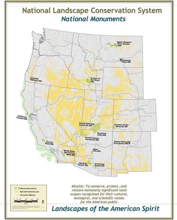
 The Bureau of Land Management's National Landscape Conservation System includes 16 national monuments in eight western states. These national monuments encompass landscapes of tremendous beauty and diversity, ranging from rugged California coastline to vividly-hued desert canyons.
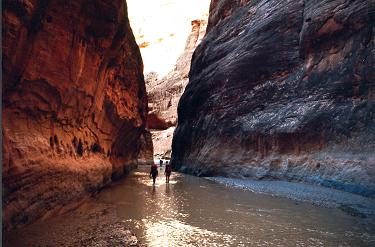