Activities of the U.S. Geological Survey in the Caribbean
The USGS administers a variety of programs in the Caribbean. In addition to Water Resources work, studies of tectonics, marine geology, biology, and geography are in progress. Some of these are highlighted below.
 Earthquake Hazards Program: The USGS Earthquake Hazards Program is part of the National Earthquake Hazards Reduction Program (NEHRP) lead by the Federal Emergency Management Agency (FEMA). The USGS role in NEHRP is to provide Earth sciences information and products for earthquake loss reduction. The goals of the USGS Earthquake Hazards Program are to improve earthquake hazard identification and risk assessment methods and their use; maintain and improve comprehensive earthquake monitoring in the United States and its territories; and to improve the understanding of earthquake occurrence and their effects andconsequences. In addition, the USGS operates a seismic station in Cayey, Puerto Rico. To obtain information about earthquakes in the Caribbean, visit the Current Seismicity for Mexico - Central America - Caribbean web page. Earthquake Hazards Program: The USGS Earthquake Hazards Program is part of the National Earthquake Hazards Reduction Program (NEHRP) lead by the Federal Emergency Management Agency (FEMA). The USGS role in NEHRP is to provide Earth sciences information and products for earthquake loss reduction. The goals of the USGS Earthquake Hazards Program are to improve earthquake hazard identification and risk assessment methods and their use; maintain and improve comprehensive earthquake monitoring in the United States and its territories; and to improve the understanding of earthquake occurrence and their effects andconsequences. In addition, the USGS operates a seismic station in Cayey, Puerto Rico. To obtain information about earthquakes in the Caribbean, visit the Current Seismicity for Mexico - Central America - Caribbean web page. |
| |
|
 Soufriere Hills Volcano: During unrest and the early stages of the current eruptive episode of the Soufriere Hills Volcano, a team from the USGS/USAID Office of Foreign Disaster Assistance (OFDA), Volcano Disaster Assistance Program (VDAP) based at the Cascades Volcano Observatory; assisted the Seismic Research Unit of the University of the West Indies to install and operate a monitoring network at Soufriere Hills Volcano. For the past several years, monitoring of the volcano and assessment of hazards have been the responsibility of the Montserrat Volcano Observatory. The volcano sits on the north flank of the older South Soufriere Hills volcano, located at the south end of Montserrat Island in the Lesser Antilles, eastern Caribbean. The summit area consists primarily of a series of east/southeast-trending lava domes. The volcano is 915 meters (3,010 feet) high and began the current eruptions on July 18, 1995. Soufriere Hills Volcano: During unrest and the early stages of the current eruptive episode of the Soufriere Hills Volcano, a team from the USGS/USAID Office of Foreign Disaster Assistance (OFDA), Volcano Disaster Assistance Program (VDAP) based at the Cascades Volcano Observatory; assisted the Seismic Research Unit of the University of the West Indies to install and operate a monitoring network at Soufriere Hills Volcano. For the past several years, monitoring of the volcano and assessment of hazards have been the responsibility of the Montserrat Volcano Observatory. The volcano sits on the north flank of the older South Soufriere Hills volcano, located at the south end of Montserrat Island in the Lesser Antilles, eastern Caribbean. The summit area consists primarily of a series of east/southeast-trending lava domes. The volcano is 915 meters (3,010 feet) high and began the current eruptions on July 18, 1995. |
| |
|
 Earthquakes and Tsunamis in Puerto Rico and the U.S. Virgin Islands: Many earthquakes and tsunamis have occurred in the northeastern Caribbean, where the movements of the Earth's surface plates are rapid and complicated. Future such events pose serious hazards to the 4 million people who live in Puerto Rico and the U.S. Virgin Islands. Work on this and related topics is in progress by the U.S. Geological Survey - Geology in the Puerto Rico and U.S. Virgin Islands. Earthquakes and Tsunamis in Puerto Rico and the U.S. Virgin Islands: Many earthquakes and tsunamis have occurred in the northeastern Caribbean, where the movements of the Earth's surface plates are rapid and complicated. Future such events pose serious hazards to the 4 million people who live in Puerto Rico and the U.S. Virgin Islands. Work on this and related topics is in progress by the U.S. Geological Survey - Geology in the Puerto Rico and U.S. Virgin Islands.
Several abstracts related to tectonics in the Caribbean are available online. |
| |
|
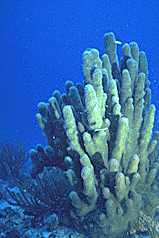 Coral and Reef fisheries: Research in the U.S. Virgin Islands includes coordinating and participating in a number of programs for long-term research and monitoring. More information is available at the U.S. Geological Survey Field Station--Biological Resources, Virgin Islands National Park, St. John, U.S. Virgin Islands Web Site. Coral and Reef fisheries: Research in the U.S. Virgin Islands includes coordinating and participating in a number of programs for long-term research and monitoring. More information is available at the U.S. Geological Survey Field Station--Biological Resources, Virgin Islands National Park, St. John, U.S. Virgin Islands Web Site. |
| |
|
 Southeastern Amphibian Research and Monitoring Initiative: The problem of declining amphibian populations has been recognized world wide, with credible reports of declines or disappearances from many regions and habitat types. No single cause has been demonstrated, although acid precipitation, environmental contaminants, the introduction of exotic predators, disease agents, parasites, and the effects of ultraviolet radiation have been suggested to be involved. Habitat loss has been and continues to be a major factor. In the United States, amphibian declines of unknown origin were first reported on the island of Puerto Rico and in the western States, where many populations tend to be small and isolated. More information is available at the U.S. Geological Survey Field Station - Biological Resources, Virgin Islands National Park, St. John, U.S. Virgin Islands Web Site. Southeastern Amphibian Research and Monitoring Initiative: The problem of declining amphibian populations has been recognized world wide, with credible reports of declines or disappearances from many regions and habitat types. No single cause has been demonstrated, although acid precipitation, environmental contaminants, the introduction of exotic predators, disease agents, parasites, and the effects of ultraviolet radiation have been suggested to be involved. Habitat loss has been and continues to be a major factor. In the United States, amphibian declines of unknown origin were first reported on the island of Puerto Rico and in the western States, where many populations tend to be small and isolated. More information is available at the U.S. Geological Survey Field Station - Biological Resources, Virgin Islands National Park, St. John, U.S. Virgin Islands Web Site.
|
| |
|
 Sirenia Project: The Florida Caribbean Science Center´s Sirenia Project conducts long-term, detailed studies on the life history, population dynamics, and ecological requirements of the West Indian manatee (Trichechus manatus). Sirenia Project biologists work cooperatively with federal and state researchers and managers on research identified as essential for the recovery of the species. For more information, see the U.S. Geological Survey Florida Caribbean Science Center, Gainesville, Florida Web Site. Sirenia Project: The Florida Caribbean Science Center´s Sirenia Project conducts long-term, detailed studies on the life history, population dynamics, and ecological requirements of the West Indian manatee (Trichechus manatus). Sirenia Project biologists work cooperatively with federal and state researchers and managers on research identified as essential for the recovery of the species. For more information, see the U.S. Geological Survey Florida Caribbean Science Center, Gainesville, Florida Web Site. |
| |
|
 Coral Mortality and African Dust: It is possible that Saharan dust, deposited in the western Atlantic, plays a role in coral die offs in the Caribbean. Work on this and related topics is in progress by the U.S. Geological Survey Center for Coastal Geology and Regional Marine Studies, St. Petersburg, Florida. Coral Mortality and African Dust: It is possible that Saharan dust, deposited in the western Atlantic, plays a role in coral die offs in the Caribbean. Work on this and related topics is in progress by the U.S. Geological Survey Center for Coastal Geology and Regional Marine Studies, St. Petersburg, Florida. |
| |
Caribbean Water Science Center Home Page
|

