Watershed Deposition Tool
AMAD Research Programs
Linking Air Quality to Ecosystem Exposure
Background
Atmospheric wet and dry deposition can be important contributors to total pollutant loadings in watersheds. Since deposition can be expensive to monitor over an entire watershed, estimates of deposition are often obtained from regional scale air quality models such as the EPA’s regional-scale, multi-pollutant Community Multiscale Air Quality model (CMAQ). CMAQ can be used to estimate deposition resulting from a number of scenarios including current conditions and future emissions reductions that are expected due to rules such as Clean Air Interstate Rule (CAIR) and Clean Air Mercury Rule (CAMR). CMAQ produces gridded output with typical grid sizes of 36, 12, and 4 km. Since watersheds do not conform to the grid layout of CMAQ, additional tools must be used to map the results from CMAQ to the watersheds to provide the linkage between air and water needed for TMDL (Total Maximum Daily Load) and related nonpoint-source watershed analyses. This linkage then allows water quality management plans to include the reductions in atmospheric deposition produced by the air regulatory community in their calculation of loadings to the watershed.
Overview of the Watershed Deposition Tool
The Watershed Deposition Tool (WDT) was developed by the Atmospheric Modeling Division to provide an easy to use tool for mapping the deposition estimates from CMAQ to watersheds to provide the linkage between air and water needed for TMDL (Total Maximum Daily Load) and related nonpoint-source watershed analyses. This software tool takes gridded atmospheric deposition estimates from EPA’s regional, multi-pollutant air quality model, CMAQ, and allocates them to 8-digit HUC’s (hydrologic cataloging units of rivers and streams) within a watershed, State or Region. The WDT can calculate the weighted average CMAQ atmospheric deposition (wet, dry, wet + dry) across a selected HUC or a set of selected HUC’s for a given scenario. The WDT can also calculate the average change in air deposition across a HUC between two different air deposition simulations. Calculations can be exported to CSV files. For experienced GIS users the WDT can also export GIS Shape files of the CMAQ gridded outputs. The tool is designed to work under the Microsoft Windows system.
Deposition Components Available from CMAQ
- Nitrogen
- Dry Oxidized Nitrogen
- Wet Oxidized Nitrogen
- Total (Wet+Dry) Oxidized Nitrogen
- Dry Reduced Nitrogen
- Wet Reduced Nitrogen
- Total (Wet + Dry) Reduced Nitrogen
- Total Dry (Reduced + Oxidized) Nitrogen
- Total Wet (Reduced + Oxidized) Nitrogen
- Total (Reduced + Oxidized) Nitrogen
- Sulfur
- Total Wet Sulfur
- Total Dry Sulfur
- Total (Wet + Dry) Sulfur
- Mercury
- Total Wet Mercury
- Total Dry Mercury
- Total (Wet + Dry)Mercury
Download the Watershed Deposition Tool (vs 1.4.14)
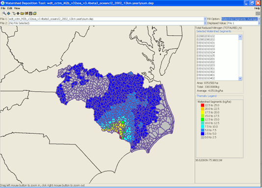 Screen shot of the 2002 annual CMAQ total reduced nitrogen deposition mapped to watersheds draining into the Albemarle-Pamlico Sound displayed in GIS mapping software. |
Contacts: Donna Schwede, Robin Dennis
Relevant Publications & Presentations:
Schwede, D., R. Dennis, M. Bitz. The Watershed Deposition Tool: A tool for incorporating atmospheric deposition in water-quality analyses. Submitted to Journal of the American Water Resources Association (2008).