
 Feeds & Data
M2.6 – Southern California
Tuesday, April 21, 2009 at 08:11:03 UTC
Tuesday, April 21, 2009 at 01:11:03 Local
Tuesday, April 21, 2009 at 01:11:03 Local
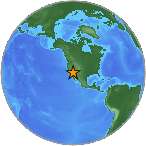
34.18°N 117.07°W
Depth: 4km


| Location | MMI | Resp. | Distance | Latitude | Longitude |
|---|---|---|---|---|---|
| Norwalk, CA (90650) | 2 | 1 | 98 | 33.91°N | 118.08°W |
| Pico Rivera, CA (90660) | 2 | 1 | 96 | 33.99°N | 118.09°W |
| Palm Springs, CA (92264) | 2 | 1 | 69 | 33.74°N | 116.54°W |
| Angelus Oaks, CA (92305) | 2 | 1 | 17 | 34.17°N | 116.87°W |
| Highland, CA (92346) | 2 | 3 | 12 | 34.12°N | 117.18°W |
| San Bernardino, CA (92407) | 1 | 1 | 22 | 34.17°N | 117.31°W |
| Aliso Viejo, CA (92656) | 2 | 1 | 91 | 33.57°N | 117.73°W |
| Anaheim, CA (92801) | 2 | 1 | 89 | 33.84°N | 117.95°W |
| Placentia, CA (92870) | 3 | 1 | 80 | 33.88°N | 117.86°W |
| Palmdale, CA (93551) | 2 | 1 | 115 | 34.60°N | 118.22°W |
| San Francisco, CA (94107) | 2 | 1 | 623 | 37.76°N | 122.39°W |
| Napa, CA (94558) | 2 | 1 | 669 | 38.50°N | 122.27°W |
- City mapJPG | PDF | PSMap of responses by city or ZIP code
- Intensity vs. DistanceJPG | PSPlot of Attenuation (fall-off) with distance for each intensity versus its distance from the epicenter
- Responses vs. TimeJPG | PSPlot of total number of responses since the event
- Product ListXMLList of available DYFI maps and data for this event
- Intensity SummaryTXT | XMLTable of intensities aggregated by city or ZIP code
