WSR-88D Doppler Radar
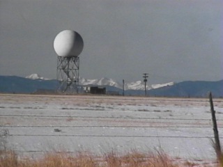 The WSR-88D (Weather Surveillance Radar 1988 Design Doppler) was installed in extreme northeast Pueblo County (about 18 miles northeast of the WFO Pueblo office) in December 1994, and commissioned for official use the second week of August 1995. This location is the best for tracking both thunderstorms and snow events over our 21 county warning and forecast area. While the Doppler radar obviously cannot see through the mountains, it can see storms well into the high country west of Colorado Springs, and can see the mid- and high-level structure of storms over the San Luis Valley and surrounding mountains. Therefore, across the southeast Colorado plains, where most of our severe weather occurs, the Doppler radar has an unobstructed view of thunderstorms and lesser weather. Reflectivity and velocity data is collected by the radar and transmitted via a high speed communications line to WFO Pueblo, where the data is processed and displayed. A feature of the Doppler radar is its high power output, and therefore, its sensitivity. It can actually detect cloud droplets, atmospheric aerosols (tiny particles in the air), and bugs in the air on the output screen. As a consequence, the radar shows cool air outflow boundaries from showers and thunderstorms, which can be tracked, and can initiate further thunderstorm development elsewhere in our area. Cold fronts can also be monitored on the radar. The Doppler's ability to detect wind speed and wind direction in storms, and throughout the general area, allows the staff to see anything from the beginnings of a tornado circulation in a thunderstorm, to the areawide upslope and downslope events that so profoundly influence our weather in southern Colorado.
The WSR-88D excells in detecting severe weather events that threaten life and property, such as large hail, damaging winds, tornados, and locally heavy, flooding rain. Sever weather warnings can be issued for a more specific area, lessening the false alarm rate for short-lived events such as hail, damaging winds, tornados, and flash floods, and you have more time to take cover.
|

For general information on how Doppler Radar works, see http://www.srh.noaa.gov/srh/jetstream/doppler/doppler_intro.htm

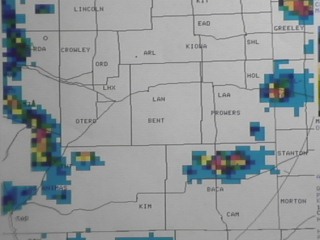
Radar and HailThe Doppler radar has a couple of different products which help meteorologists more easily assess whether a thunderstorm contains large hail. The Vertically Integrated Liquid (VIL) product has provided radar operators a quick way to determine the presence of large hail within a thunderstorm. Below is a VIL product.
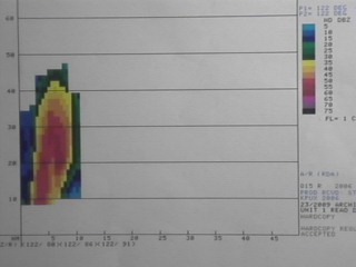
The yellow, orange, and red colors usually indicate much rainfall and large hail. A severe thunderstorm warning can be issued by WFO Pueblo for that severe hail immediately, even BEFORE receiving reports from citizens in that area. Another way the radar operator can look at a storm is with the cross-section product. This lets him/her look a slice of the storm from lower to higher heights. The image below shows a cross-section. . A severe storm will often have an extreme updraft, sometimes exceeding 100 mph, which corkscrews up into the upper parts of the storm. This updraft can punch the majority of the raindrops and hailstones out of the updraft core area, and throw them to areas all around the updraft core. In the image above, you can see this narrow core of lesser reflectivity, which shows the position of the extreme updraft. This narrow core of lesser reflectivity, surrounded by higher reflectivity (heavy rain and hail), is called a Bounded Weak Echo Region (BWER). It points to the extreme, twisting updraft with a very high probability of severe hail, damaging winds, and even a tornado in that area of the storm. |
|
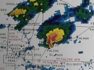
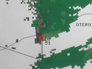
Radar and Damaging Winds and TornadoesThe Doppler radar helps the radar operator immensely in determining whether a thunderstorm contains damaging winds or even a tornado. On June 22, 1995 a thunderstorm developed near Palmer Lake in far northwest El Paso county. The storm split in half, one part moving north across the Palmer Divide, the other moving east southeast toward Black Forest and Falcon. The southern storm did not have high winds or severe hail for several minutes, but the Pueblo Doppler radar did show a suspicious shape in the reflectivity product shown below.
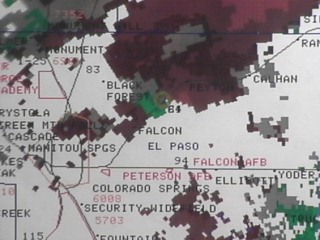
The storm had an extension, dipping southward on its western side, called a pendant. The radar was sounding alarms for rotation in the western part of the storm. The product below is the wind detection part of the radar.
It shows strong airflow toward the radar (green). On either side of the inbound (green) airflow, is strong airflow away from the radar (reds). Where the radar detects strong counterclockwise rotation, it prints out a mustard colored "donut", a mesocyclone. The clockwise rotation was weaker. The brief, narrow, but destructive tornado occurred at the mustard colored "donut" (mesocyclone) position seen in the above product. When the Doppler radar detects a very narrow and intense circulation with a thunderstorm, a Tornado Vortex Signature (TVS) is displayed on the radar screen, as seen below as a red, upside down triangle.
Its appearance sometimes means a tornado circulation has already made it to the ground, or will shortly. |
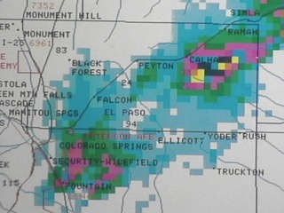
Radar and FloodingThe Doppler radar has an algorithm (computer program) that attempts to estimate the amount of rain that has fallen across the area. This running total of rainfall allows WFO Pueblo to quickly assess the potential for flooding. We can often tell the difference between nuisance flooding and life-threatening flooding from the radar estimates. Often when radar rainfall estimates reach just over one inch an hour, the Pueblo office will issue an Urban/Small Stream Flood Advisory. This is nuisance or inconvenience flooding. When radar estimates reach three or four or more inches, it's usually wise to issue a Flash Flood Warning. Such was the case on a June night in northeast El Paso county. The image below shows the Storm Total Precipitation (STP) product late in the evening that night.
A nearly stationary strong thunderstorm dumped over five inches of rain in a two hour period. There was extensive flooding of the Black Squirrel Creek basin in eastern El Paso county. The above scenario is repeated nearly a dozen times a year in our County Warning Area. |