Skip Navigation
NOAA
weather.gov
NOAA National Weather Service Weather Forecast Office
Riverton, WY
Search for:
NWS
All NOAA
Home
Site Map
News
Organization
Local forecast by
"City, St" or Zip Code
Current Hazards
Watches / Warnings
Outlooks
U.S. Hazards
Hurricane Info
Safety Rules
Reports
eSpotter
Current Conditions
Observations
Satellite Images
Rivers & Lakes AHPS
Precip Estimate
Snow Cover
AWOS Observations
Road & Travel
Quick Brief
24 Hour Summary
Latest Snowfall Map
Radar Imagery
Local Radar
Nationwide
Low Bandwidth Radar
Forecasts
Activity Planner
Local Area
Aviation
Fire Weather
Graphical
Interactive
Graphical - Local
Weekend Weather Graphics
Yellowstone/Grand Teton NP
Avalanche
Local Aviation
Forecast Icon Legend
Rivers / Hydrology
AHPS / River Info
Flash Floods
Hydro Products
Climate
Local
National
More...
Weather Safety
StormReady
Weather Radio
EMWIN
Spring/Summer
Winter
Local Information
Our Office
Coop Observer
SchoolNet
Webcams
Office Staff
Spotters
NWS Offices
Past News Stories
News of the Day Archive
FAQ
Outreach
Diversity
Contact Us
Webmaster
Feedback
Home
> Satellite
GOES 10 Satellite Images
Resolution and Links
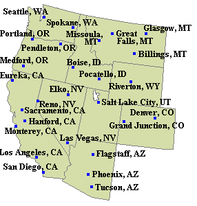
Click on map for city-centered 1km visible image.
Visible
1km
animation
2km
animation
4km
animation
Infrared
2km
animation
4km
animation
Water Vapor
4km
animation
16km
animation
Fog
2km
animation
Resolution:
1 km = Wyoming
2 km = Intermountain Region
4 km = Western U.S.
16 km = North America and E. Pacific
NOAA National Weather Service
Riverton, WY Weather Forecast Office
12744 West U.S. Hwy 26
Riverton, WY 82501
307-857-3898
Page Author: RIW Webmaster
Web Master's E-mail:
w-riw.webmaster@noaa.gov
Page last modified: 8-Nov-2005 4:53 PM UTC
Disclaimer
Credits
Glossary
Privacy Policy
About Us
Career Opportunities