
 Feeds & Data
Magnitude 6.7 - SOUTH SANDWICH ISLANDS REGION
2009 April 16 14:57:06 UTC
Earthquake Details
| Magnitude | 6.7 |
|---|---|
| Date-Time |
|
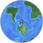
| Location | 60.187°S, 26.845°W |
| Depth | 20 km (12.4 miles) set by location program |
| Region | SOUTH SANDWICH ISLANDS REGION |
| Distances | 135 km (85 miles) S of Bristol Island, South Sandwich Islands 390 km (240 miles) S of Visokoi Island, South Sandwich Islands 885 km (550 miles) SE of Grytviken, South Georgia 3330 km (2070 miles) N of South Pole, Antarctica |
| Location Uncertainty | horizontal +/- 6.9 km (4.3 miles); depth fixed by location program |
| Parameters | NST=149, Nph=149, Dmin=>999 km, Rmss=0.79 sec, Gp= 43°, M-type=centroid moment magnitude (Mw), Version=A |
| Source |
|
| Event ID | us2009fma2 |
- This event has been reviewed by a seismologist.
- Did you feel it? Report shaking and damage at your location. You can also view a map displaying accumulated data from your report and others.
Earthquake Maps
Earthquake Location
Location Maps
ShakeMap
PAGER
Population Exposure
Google Map
Google Earth KML
(Requires Google Earth)- Did you feel it? Report shaking and damage at your location. You can also view a map displaying accumulated data from your report and others.
Scientific & Technical Information

- Preliminary Earthquake Report
- U.S. Geological Survey, National Earthquake Information Center:
World Data Center for Seismology, Denver
