Omnibus Public Lands Management Act of 2009
 Regular Size Maps of BLM Designations
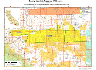
Below are links to regular size maps of designated areas under the Omnibus Public Lands Management Act of 2009, signed by President Barack Obama on March 30, 2009. Although these are not the official legislative copies, they contain the same content as the official legislative maps, including boundaries, land status, and geographic features but are formatted to print on a regular printer at a size of 8½ x 11 inches. The file size of these maps is also significantly smaller (all are less than 1.2 Mb in size), thus allowing for a faster download. Unfortunately, as with the case of all maps, they cannot be made section 508 compliant. For our users that require special accessibility, please contact the appropriate State Office which is annotated on each link below.
Click here to access the large size maps (official legislative copies), formatted to print on a plotter.
California
Riverside County (Title I, Subtitle L)
Colorado
Idaho
Owyhee Lands (Title I, Subtitle F)
New Mexico
Oregon
Cascade-Siskiyou National Monument (Title I, Subtitle E)
Badlands Wilderness (Subtitle I)
Spring Basin Wilderness With Land Exchange (Title I, Subtitle J)
Utah
Washington County (Title I, Subtitle O)