Printable Maps

Do you need a simple prepared map that you can print at home, at school, or in the office? Look below at our expanding list of maps formatted to be viewed, printed, or downloaded.
| Home › Printable Maps › Territorial Acquisitions | ||
Printable Maps |
||
|
Do you need a simple prepared map that you can print at home, at school, or in the office? Look below at our expanding list of maps formatted to be viewed, printed, or downloaded. |
||
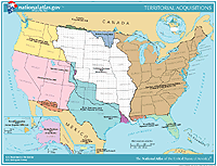
| Territorial Acquisitions of the United States | ||||||||||||||||
 Go to map list |
The National Atlas has prepared a Territorial Acquisitions map of the United States that you can print or use online. This map portrays the major acquisitions of territory by the United States from 1783 to the present. Areas in North America, the Caribbean, and Hawaii are included. The map is in color, but will also print or copy well in black and white. These map pages are in a standard 8.5- by 11-inch landscape format. The map is available in the following formats.
|
|
||||||||||||||
|
||||||||||||||||
National Atlas of the United States® and The National Atlas of the United States of America® are registered trademarks of the United States Department of the Interior Privacy Statement, Disclaimer, Accessibility, FOIA http://www.nationalatlas.gov/printable/territorialacquisition.html Last modified: Tuesday April 29 2008 |
 |
|
;)