Printable Maps

Do you need a simple prepared map that you can print at home, at school, or in the office? Look below at our expanding list of maps formatted to be viewed, printed, or downloaded.
| Home › Printable Maps › Satellite View | ||
Printable Maps |
||
|
Do you need a simple prepared map that you can print at home, at school, or in the office? Look below at our expanding list of maps formatted to be viewed, printed, or downloaded. |
||
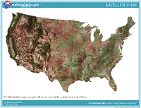
| Satellite View | ||||||||||||||||||||||||||
 Go to map list
 |
The first Landsat satellite began beaming views of our planet back to Earth in 1972. Since then, five more of these satellites have delivered millions of new images from more than 400 miles in space. The Earth is covered by new Landsat images every sixteen days. Scientists, planners, and land managers use these to study the world's agriculture, geology, forests, and more. The Satellite View map is a colorful mosaic of dozens of Landsat images. And we've added in terrain information so that the landforms of the Conterminous States are apparent too. The maps are available in the following formats.
|
|
||||||||||||||||||||||||
|
||||||||||||||||||||||||||
National Atlas of the United States® and The National Atlas of the United States of America® are registered trademarks of the United States Department of the Interior Privacy Statement, Disclaimer, Accessibility, FOIA http://www.nationalatlas.gov/printable/satellite.html Last modified: Tuesday April 29 2008 |
 |
|
;)