to the National Atlas Home page
About | Contact Us | Partners | Products | Site Map | FAQ | Help 
AgricultureBiologyBoundariesClimateEnvironmentGeologyGovernmentHistoryMappingPeopleTransportationWater
to the Interactive Map MakerMap LayersPrintable MapsWall MapsDynamic MapsArticlesMapping Professionals
 

Printable Maps

 
  printer icon

Do you need a simple prepared map that you can print at home, at school, or in the office? Look below at our expanding list of maps formatted to be viewed, printed, or downloaded.


  Precipitation of the Individual States and of the Conterminous States
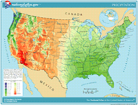
  Precipitation map of the U.S. Go to map listdown arrowto view and print Precipitation of the individual States and of the Conterminous United States

This colorful series of maps illustrates the average annual precipitation from 1961 through 1990. Maps were prepared for individual States and for the Conterminous States. Each color on the maps represents a range of precipitation values in inches, from just a few to nearly 200 inches.

The maps are available in the following formats.

  • GIF (Graphics Interchange Format)
    These maps are for use on the World Wide Web and can be viewed in your browser window.
    File Sizes: Each map page in GIF format is between 40 - 93KB (127KB for Conterminous States).

  • PDF (Portable Document Format)
    These maps can be printed using your home or office printer. Each map is designed to fit a 8.5- by 11-inch sheet of paper.
    File Sizes: Each map page in PDF format ranges from 161kb to 1MB (5MB for Conterminous States).

    You will need Adobe Acrobat Reader software to view and print PDF files.
    Get adobe Reader

Boundaries
Map Maker
States
Time Zones
Map Layers
States
Time Zones
Wall Maps
General Reference Maps

Climate
Map Maker Sample
Average Annual Precipitation 1961-1990
Articles
Snow Surveys and Water Supply Forecasting
Map Layer
United States Average Annual Precipitation, 1961-1990

Water
Map Maker
Streams and Waterbodies
Map Layer
Streams and Waterbodies


back to topup arrow


Printable Maps List: Precipitation of the Individual States and of the Conterminous States
48 States | AL | AR | AZ | CA | CO | CT |DE | FL | GA |IA | ID | IL | IN | KS | KY | LA | MA | MD | ME | MI | MN | MO | MS | MT | NC | ND | NE | NH | NJ | NM | NV | NY | OH | OK | OR | PA | RI | SC | SD | TN | TX | UT | VA |VT | WA | WI | WV | WY

Map Name

GIF Preview Map (40 - 127KB) Print PDF Map (161KB - 5MB)
Conterminous States Preview map Print PDF Map
Alabama Preview map Print PDF Map
Arizona Preview map Print PDF Map
Arkansas Preview map Print PDF Map
California Preview map Print PDF Map
Colorado Preview map Print PDF Map
Connecticut Preview map Print PDF Map
Delaware Preview map Print PDF Map
Florida Preview map Print PDF Map
Georgia Preview map Print PDF Map
Idaho Preview map Print PDF Map
Illinois Preview map Print PDF Map
Indiana Preview map Print PDF Map
Iowa Preview map Print PDF Map
Kansas Preview map Print PDF Map
Kentucky Preview map Print PDF Map
Louisiana Preview map Print PDF Map
Maine Preview map Print PDF Map
Maryland Preview map Print PDF Map
Massachusetts Preview map Print PDF Map
Michigan Preview map Print PDF Map
Minnesota Preview map Print PDF Map
Mississippi Preview map Print PDF Map
Missouri Preview map Print PDF Map
Montana Preview map Print PDF Map
Nebraska Preview map Print PDF Map
Nevada Preview map Print PDF Map
New Hampshire Preview map Print PDF Map
New Jersey Preview map Print PDF Map
New Mexico Preview map Print PDF Map
New York Preview map Print PDF Map
North Carolina Preview map Print PDF Map
North Dakota Preview map Print PDF Map
Ohio Preview map Print PDF Map
Oklahoma Preview map Print PDF Map
Oregon Preview map Print PDF Map
Pennsylvania Preview map Print PDF Map
Rhode Island Preview map Print PDF Map
South Carolina Preview map Print PDF Map
South Dakota Preview map Print PDF Map
Tennessee Preview map Print PDF Map
Texas Preview map Print PDF Map
Utah Preview map Print PDF Map
Vermont Preview map Print PDF Map
Virginia Preview map Print PDF Map
Washington Preview map Print PDF Map
West Virginia Preview map Print PDF Map
Wisconsin Preview map Print PDF Map
Wyoming Preview map Print PDF Map
 

back to topup arrow