NWS Twin Cities Home Page » NOAA All Hazards Weather Radio
![]()
 |
You can now listen to NOAA Weather Radio All-Hazards live on the internet by clicking here!
|
|
||||||||||
|
||||||||||
|
||||||||||
|
||||||||||
|
||||||||||
|
||||||||||
|
||||||||||
|
There are more than 900 NWR transmitters across the United States. Broadcasts can be heard on the public service band on the following seven frequencies (MHz): 162.400, 162.425, 162.450, 162.475, 162.500, 162.525 and 162.550. NWR coverage is expanding through partnership programs with local communities. For a listing of all NWR transmitters across the United States, check out the national NWR web page.
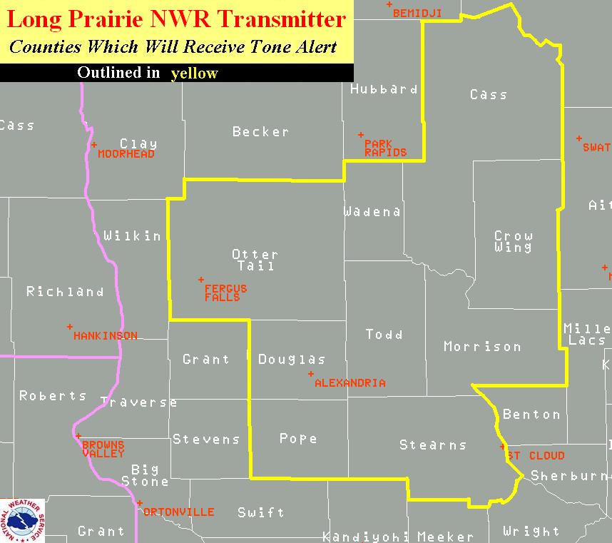
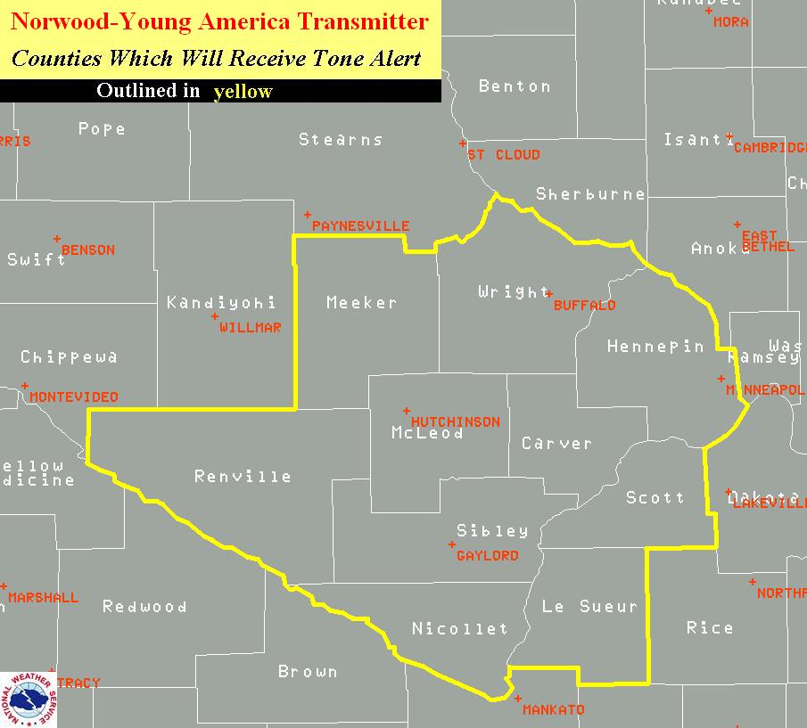
The first step of programming your NWR unit is setting the broadcast channel to the correct transmitter frequency. The NWS Forecast Office in Chanhassen delivers broadcast programming for a total of 13 NWR transmitters. Information on these is found in the table below. Click on the the map under the "Counties" section of each transmitter to get a geographical depiction of the particular transmitter alert area.
|
Call Letters |
Location |
Frequency |
Coverage Area Descriptor |
Counties |
||
|
KEC-65 |
St. Paul, MN
(Twin Cities Metro Area)
|
162.550 |
East central Minnesota and west central Wisconsin, including the Minneapolis/St Paul metro area. |
|
||
|
WXL-65 |
St. Cloud, MN |
162.400 |
Portions of central Minnesota, including the greater St. Cloud area. |
|
||
|
WXK-44 |
New London, MN (Willmar Area) |
162.475 |
Portions of central Minnesota, including Willmar and Litchfield. |
|
||
|
WXK-40 |
Janesville, MN(Mankato Area) |
162.400 |
South central Minnesota, including the greater Mankato area. |
|
||
|
WXJ-88 |
Wheeler, WI (Eau Claire Area) |
162.400 |
Much of west central Wisconsin, including Eau Claire, Menomonie, and Chippewa Falls. |
|
||
|
KXI-39 |
New Ulm |
162.525 |
Portions of south central Minnesota, including New Ulm and St. James. |
|
||
|
KNG-577 |
Tony, WI (Ladysmith, WI Area) |
162.550 |
Portions of northwest Wisconsin, including Ladysmith. |
|
||
|
WNG-673 |
Long Prairie |
162.525 |
A portion of central Minnesota, including Long Prairie and Little Falls. |
|
||
|
WNG-676 |
Clearwater |
162.500 |
Portions of central Minnesota, stretching from the northern Twin Cities metro area up through St Cloud. |
|
||
|
WNG-685 |
Norwood-Young America |
162.425 |
A small portion of central Minnesota stretching from the southwest Twin Cities suburbs westward through Hutchinson. |
|
||
|
WNG-707 |
Kensington |
162.400 |
A portion of west central Minnesota, including the Alexandria area. |
|
||
|
WNG-711 |
Olivia |
162.400 |
A portion of central and southwestern Minnesota, including Redwood Falls and Olivia. |
|
||
|
KJY-80 |
Red Wing |
162.450 |
Portions of east central and southeastern Minnesota, and west central Wisconsin. Broadcast area includes Red Wing, Hastings and River Falls. |
|
||


You can also find your county by this tabular listing alphabetized by county.
|
|
|
|
| Central and South Central Minnesota NOAA Weather Radio Coverage | Western Wisconsin NOAA Weather Radio Coverage |


|
NWR Computer Derived Signal Coverage Maps:
|
These computer derived signal coverage maps are calculated using a computer model and station data under ideal conditions. The maps are shown in a three color format, which relates to the three estimated broadcast signal levels:
White: Signal level of greater than 18 dbd usually indicates reliable reception.
Green: 0 dbd to 18 dbd usually indicates that signal reception is possible but unreliable.
Pink: Less than 0 dbd usually indicates that the signal will not be received.
With the implementation of the Emergency Alert System (EAS) and Specific Area Message Encoding (S.A.M.E.), it is now possible to program most weather radios to sound an alert for only the counties desired in a specific NWR's broadcast area. The owner of a NWR receiver with S.A.M.E. technology would program the desired county or counties into the radio. It will then alert the user only to weather emergencies for the specific area(s) programmed. Older (non-S.A.M.E.) NWR receivers without S.A.M.E. capability would alert for emergencies anywhere within the coverage area of the NWR transmitter, even though the emergency could be well away from the listener. The S.A.M.E. technology can eliminate this appearance of over-warning.
 |
|
Area S.A.M.E. Codes
(Click to Enlarge)
|
The links below provide a text listing of NWR S.A.M.E. County Codes:
Minnesota | Wisconsin | Other States
When the NWS broadcasts an urgent audio message, a digital S.A.M.E. burst of information is also broadcast. This S.A.M.E. code contains information on the type of message, county(s) affected, and expiration time of the message (the S.A.M.E. code broadcast can be heard as three brief bursts of static). An appropriately programmed NWR with S.A.M.E. technology will then turn on upon receiving the information burst.
|
Tone Alerted Products by the NWS Chanhassen, MN Weather Forecast Office:
|
|
|
Weather
|
Non-Weather^
|
|
Blizzard Warning
|
Civil Danger Warning
|
|
Flash Flood Warning
|
Evacuation Immediate Warning
|
|
Routine Weekly Test*
|
Fire Warning
|
|
Severe Thunderstorm Warning
|
Hazardous Materials Warning
|
|
Severe Thunderstorm Watch
|
Law Enforcement Warning
|
|
Tornado Warning
|
Nuclear Power Plant Warning
|
|
Tornado Watch
|
Radiological Hazards Warning
|
|
Any Weather Appearing Life-Threatening
|
Shelter-In-Place Warning
|
Each NWS local office tailors their broadcasts to the local listening areas. There are "routine," "severe weather watch," and "severe weather warning" broadcasts. NWR broadcast programming changes significantly during the latter two and focus on keeping you informed of the latest severe weather statements and warnings.
A test of the NWR warning alarm is conducted by the National Weather Service Forecast Office in Chanhassen, MN every Wednesday afternoon around 1 PM. If severe weather threatens near the normal test time, the test will be postponed until the first available good weather day. Receipt of this test is the most preferred way to ensure your radio is programmed correctly to receive watches and warnings!
The routine broadcast schedule for each of our NWR transmitters includes the following:
- A regional synopsis and general forecast for the five state region including Minnesota, Wisconsin, Iowa and the eastern Dakotas.
- The 7-day local forecast specified for the transmitter coverage area. This is updated a minimum of two times daily, and more frequently as conditions change.
-
Current weather conditions for cities in Minnesota and across the Upper Midwest. These are broadcast continuously and updated hourly.
- A Hazardous Weather Outlook highlighting chances for any potentially hazardous weather in the next seven days. This includes a message for our Skywarn storm spotters about possible activation. The outlook will play each day from roughly 4:30 to 10:30 am, unless there is a threat of severe weather later that day or night, in which case it will play through the duration of the threat.
- A short term forecast is broadcast when precipitation and other significant weather events are occurring across the area.
- Daily climate data is broadcast from 8:00 to 10:00 A.M. and from 7:00 to 10:00 P.M., if available. Monthly climate summaries are broadcast on the first three days of each month, from Noon to 7:00 P.M. where available.
- HazCollect Brochure
- Wisconsin HazCollect Oversight Committee By-Laws
- Wisconsin HazCollect Participation Guidelines