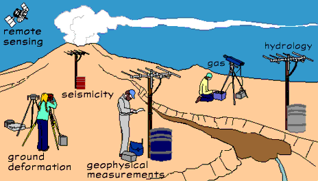
How We Monitor Volcanoes

The USGS Volcano Hazards Program monitors volcanoes for signs of unrest (activity). We analyze and interpret the data we collect from our networks of instruments. The data and an understanding of what the data have meant in the past are crucial for determining when a volcano might erupt.
Most data can be accessed from our offices in the observatories but visits to the volcanoes, when possible, add valuable information.
When a volcano begins to show
new or unusual signs of activity, our monitoring data help us answer
critical questions necessary for assessing and then communicating
timely information about volcanic hazards. For example, prior to
the 2005 activity at Mount St. Helens our monitoring equipment
recorded a large increase in earthquake activity. Scientists quickly
examined other monitoring data including gas, ground deformation, and
satellite imagery to assess if a magma
or fluid was moving towards the surface. Based on the history of the
volcano and the analysis of the monitoring data we were able to
determine what types of materials could be moving towards the surface.
The possible magma and fluid compositions helped us figure out what
types of hazards could potentially occur. The possible types of
hazards help determine what real-time warnings
are needed to prevent loss of life and property damage.
Types of Monitoring Techniques