
|

The 1950 eruption was the largest and most spectacular eruption from the southwest rift zone of Mauna Loa since written records have been kept. It was especially noteworthy, for lava was erupted from a nearly continuous 20-km-long fissure along the middle portion of the rift zone. One of the significant things about this eruption is that the flows reached the sea in less than four hours.
The 1950 Mauna Loa eruption began on June 1. It followed the summit eruption of 1949 by almost one year, consistent with Mauna Loa's pattern of flank eruptions succeeding summit eruptions within two years. On the 50th anniversary of the eruption, this article summarizes the high (and low) points of the eruption.
At 5:43 a.m. on March 25, 1950, a strong earthquake was felt across the island. On May 29 at 3:17 p.m., two days before the eruption, another strong earthquake shook the island. The epicenter was high on the southwest rift zone. Kona residents reported damage to water tanks and stonewalls. The late May earthquake and aftershocks signaled volcanic unrest and an imminent eruption.
Another swarm in early June directly preceded and accompanied the eruptive outbreak. Volcanic tremor appeared on seismographs at the Hawaiian Volcano Observatory at 9:04 p.m. on June 1. Six minutes later, Mr. and Mrs. Hansen from Na`alehu reported hearing rumbling sounds.
Soon after, at 9:25 p.m., the distinctive eruption glow appeared on the skyline of the southwest rift zone. Observers reported that a 4.0-km-fissure opened near the pit crater, Lua Hou (3,840 m), and propagated downrift to near Sulphur Cone (3,350 m). A lava flow from this fissure headed westward down the mountain (fig. 1) . This initial flow moved toward Ho`okena but advanced only 8 km to the 2,740-m elevation.

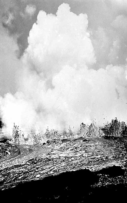
A second and more robust flow moved south-southeastward toward Punalu`u (figs. 2 and 3). By daybreak on June 2, this flow crossed Kahuku Ranch's upper pasture road. The flow entered the upper reaches of the Ka`u Forest Reserve after flowing approximately 16 km to the 1,670-m elevation (fig. 2).
|
Figure 3. Line of fountains from the 3160-m elevation feeds the Punalu`u flow. The plume cloud hovering above the fountains was the first indication to scientists that activity migrated downrift.
Credit: Honolulu Star Bulletin |
 |
At 10:15 p.m. on June 1, HVO personnel noticed a second fume cloud 13 km downrift from the previous vents. At 10:23 p.m., a bright glow appeared in the fume cloud, indicating that lava had reached the surface. The illuminated area quickly expanded, which meant that the fissures were rapidly propagating. Vigorous lava fountains jetted into the air 45 to 60 m, with occasional bursts to 90 m.
Visual observations confirmed two en echelon fissure systems active in this region. The upper system extended from 3,200 to 2,590 m along 9.6 km of the rift zone. The second, lower fissure system reached from the 2,500- to the 2,380-m elevation. Lava from the fissures flowed in anastomosing (braided) streams heading in a westward direction. The higher fissure system produced two `a`a flows that crossed Highway 11, blocking the only road around the island.
The northernmost flow, the Honokua flow, was fed from the fissure between 2,740 and 3,050 m (fig. 2) . At 12:20 a.m. on June 2, the Honokua flow was approximately 1.5 km above Highway 11. By 12:30 a.m., it crossed the highway at the town of Pahoehoe, taking out a gas station, the post office, and several homes. The `a`a flow continued toward the ocean and reached it at 1:05 a.m. This flow covered the 24-km journey in less than 3 hours. By daylight the activity was greatly diminished, and by noon the flow had ceased at this locality.
The second flow across the highway, the Ka`ohe flow, originated from the upper fissure system between the 2,740- and 2,440-m elevation. The Ka`ohe flow crossed the highway at 5:00 a.m. on June 2, approximately 2 km south of the Honokua flow near the Magoon Ranch (fig. 1) . This `a`a flow destroyed several homes and a coconut grove at the coast as it traversed toward the sea, entering the ocean at around noon. Twenty-four hours later, activity in the Ka`ohe flow ceased. (fig. 2) .
While the main Ka`ohe lobe was active, a new `a`a flow broke off from it. The offshoot traveled farther south, was not quite as robust as the main flow, and reached within 500 m of the highway but never crossed it.
Although all this activity was ongoing, the dike wasn't finished yet. Late in the evening of June 1, it continued to propagate farther downrift. This lowest fissure system created at the 2,500- to 2,380-m elevation, produced another `a`a flow, called the Ka`apuna flow (fig. 4). The Ka`apuna can be identified today as the young, treeless flow north (Kona side) of Miloli`i on Highway 11. (fig. 2) .

At 12:20 p.m. on June 2, observatory personnel, police and lava groupies/enthusiasts were waiting on Highway 11 at the `Ohi`a Lodge (fig. 1) , anticipating the arrival of the Ka`apuna flow through the forest. At 12:30 p.m. a National Guard plane making an overflight recommended that the ground observers evacuate their current location for positions farther south, as the flow was headed in their direction.
The Ka`apuna flow crossed the highway at 2:00 p.m., 400 m south of the `Ohi`a Lodge and 6.4 km south of the Ka`ohe (middle) lobe. Observatory personnel estimated lava-flow velocities in the `a`a channel at 16 to 48 km per hour. By 3:30 p.m. the Ka`apuna flow entered the sea. The lava flowed directly into the sea, unimpeded by the cooling effects of the water; the littoral explosive activity was minor (fig. 5). A line of steam 800 m out to sea demarked the submarine front of the flow (fig. 6).
 |
Figure 5. A lava river of the Ka`apuna flow entering the sea with little steam and no littoral explosion. Credit: Transpacific Airways. |
 |
Figure 6. The Ka`apuna flow of lava enters the sea. Note the huge steam cloud far to sea. The steam demarks the submarine extent of the flow. |
Late in the evening of June 2 or early on June 3, a new lobe broke out from the 2,530-m elevation. This flow, called the Kahuku flow, moved southward toward Kahuku Ranch. On June 8, this flow ceased after reaching the 1,920-m elevation, a distance of 9.3 km from its vent (fig. 2) .
After the Kahuku outbreak, the activity stabilized, with the Ka`apuna source and flow becoming the eruptive center. Lava coursed through the lava channels toward the sea. Occasionally lava breached the channels, causing the Ka`apuna flow to widen and thicken (fig. 7).

The 1950 eruption lasted for 23 days. In that time it erupted 376 million cubic meters of lava, the largest outpouring of lava from the southwest rift zone of Mauna Loa since written records have been kept. This is equivalent to about 3.5-4 year's output for the ongoing Pu`u `O`o-Kupaianaha eruption of Kilauea. This comparison illustrates how much larger eruptions of Mauna Loa can be compared with those of Kilauea.
Flows from this eruption made their way to the sea in a hurry. For example, the Honokua flow covered the 24-km (15-mile) journey, from vent to the ocean, in less than 3 hours. When an eruption ensues along the southwest rift zone of Mauna Loa, things can happen quickly.
Was this eruption unusually large and rapid? Yes and no. The eruption of 1859 produced about the same volume of lava but took more than ten times as long to do it. The summit eruption starting in 1872 supplied nearly twice as much lava in approximately 1200 days, not 23. These three eruptions are by far the largest of the past 200 years. So, the 1950 eruption was voluminous though not record breaking, and its discharge (the volume rate of eruption) was by far the greatest since records have been kept.
The URL of this page is http://hvo.wr.usgs.gov/maunaloa/history/50_06_01/