
|
|
Once
There Was a Kapoho
Yes, once there was such a place by Frances H. Kakugawa, 1999 |
|
| The 1960 Kapoho eruption and its predecessor, the 1959 summit eruption in Kilauea Iki Crater, together formed a summit-flank sequence that has been considered a model for how Kilauea "should" behave. The Kapoho eruption caused havoc in lower Puna, an idyllic rural paradise until the lava fountains and flows covered farm land and villages. The summary below continues our web series on major Kilauea eruptions, which started with the description of the Kilauea Iki eruption. |
The Buildup The First Two Days Lava Enters Ocean & Fills Higashi Pond Attempt to Save Warm Springs Kapoho Village Threatened Kuki`i-Kapoho lava barrier The Long Barrier Koa`e Village Damaged Kapoho Village Destroyed End of the Kapoho Eruption Collapse of Kilauea’s Summit Final Thoughts |
Something was amiss. The eruption in Kilauea Iki had ended on December 21, but the shallow reservoir beneath the summit of Kilauea volcano was gorged with magma, far more than before the eruption started. Rather than removing pressure, the eruption had, for all intents and purposes, created more.
And so staff members of the Hawaiian Volcano Observatory were uneasy as 1959 came to an end. How much longer could the volcano stay quiet? Would the summit erupt again?
During the last week of the year, tiny earthquakes started to record at the seismograph in Pahoa, some 40 km down the east rift zone from Kilauea’s summit (see location map). The swarm died off in early January 1960, but the next week it moved downrift and picked up in intensity. More than 1,000 earthquakes were recorded by the Pahoa station on January 12.
On that afternoon, HVO seismologists used a portable seismograph to pinpoint the source of the swarm as an area just north of Kapoho, 47 km from the summit. Half a dozen shallow earthquakes were registered each minute, although they were so small that Kapoho residents felt nothing. The situation looked bad. Almost certainly magma was intruding the area, but would it erupt as it did in a large eruption in 1955 just uprift from Kapoho, or would it stay underground as it did during a seismic crisis in 1924?
The size and frequency of the earthquakes increased sharply at about 0545 on January 13. Many of the earthquakes were felt now, and worries were heightened. By 0800 the ground was severely cracked through town, along the trace of the Kapoho fault (see map for Jan. 14). Movement along the fault was literally pulling the town apart. The ground was constantly shaking. Booming sounds accompanied the largest earthquakes and added to the turmoil. The roughly 300 residents undertook voluntary evacuation, which was completed by early evening.
|
|
|
|
 Kapoho fault in Kapoho village on January 13, 1960. Photo was taken from downthrown side of fault looking southeast. Photographer unknown. The time of the photo is also unknown, but the relaxed postures suggest that it was in mid or late afternoon, when the constant ground shaking had ended. Three of the men were HVO staff members: Harold Krivoy (short, in middle with camera and open jacket), Don Richter (fourth from right, wearing billed cap) talking to Bill Francis (wearing hard hat). |
 Pre-eruption offset of Old Railroad Bed Road along Koa`e fault north of Kapoho. The Koa`e and Kapoho faults are old structures, reactivated in April 1924, during major collapse of the Kapoho graben, and again in 1960. The faults still exist and will doubtless move in the future. Photo taken at 1500 January 13 by J.P. Eaton. |
 Koa`e fault at same location as previous photo but taken at 0930 January 15, after the start of eruption. Ground is covered with salty ash produced by the steam-driven blasts of January 13-14. Vegetation droops because of ash load. Location is only 300 m north of active fissure. Note the greater offset of the road than on the 13th. Photo by J.P. Eaton. |
The Kapoho fault forms the southeast side of the Kapoho graben, a downdropped block within and parallel to the east rift zone. The Koa`e fault forms the northwest side of the graben. By afternoon, the graben had dropped more than 1 m along the Kapoho fault through town and 1.2 m along the Koa`e fault.
But then, as evacuation was well underway, the seismicity abated, and by 1500 few earthquakes were being felt. Speculation ran rampant for the rest of the afternoon. There would be an eruption. There wouldn’t be. Lull before storm. End of crisis.
The uncertainty ended at 1935 January 13, when red glow in the night sky above Kapoho announced the 1960 eruption.
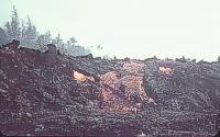
Within half an hour, fountaining was nearly continuous along a 900-m-long, segmented fissure within the graben (see map for Jan. 14). The fissure was a scant 600 m northwest of Kapoho but was within the graben rather than along the Koa`e fault. Lava spurted from the fissure in a curtain of fountains as high as 100 m. Over the next several hours, activity gradually waned at both ends of the fissure but heightened in the central part, between vents B and F. Flows of `a`a fed by the fountains moved northeastward down the gently sloping graben, at midnight crossing the Koa`e-Pohoiki Road, already broken by the Koa`e fault earlier in the day. Methane explosions from decomposing vegetation resounded through the night, accompanied by blue flames.
At about 2315 a deafening roaring sound from near vent H ushered in more than 11 hours of powerful steam blasts along the fissure system. The blasts were apparently generated as brackish water or seawater flowed into the conduits and flashed to steam. The violent expansion of the steam tore pieces, some incandescent, from the walls of the conduit and shot them upward into the billowing steam cloud. Observers likened the sound to that of a huge blowtorch or giant steam engine.
 |
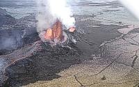
Violent steam emission from two vents
adjacent to moderate lava fountaining from two separate vents. The steam cloud in the background is dark because it carries a lot of ash in it. In the large image, note the incandescent lava particles above the fountain between the light and dark steam clouds. Photo looking uprift toward area of vent C, taken at 1000 January 14 by D.H. Richter. Left-hand lava fountain may be vent B. | med | large | |
The individual blasts lasted from a minute to more than an hour, generally puffing like the loudest steam locomotive you've ever heard. Some of the steam blasts took place next to vents fountaining lava with no steam; others alternated with lava fountains at the same vent, one minute steam, the next lava. At times, spray as if from large fire hoses spurted out at low angles from a vent that was simultaneously producing towering clouds of ash and steam.
The resulting fallout coated everything with a thin film of fine, wet, glassy ash. Salt crystals formed as the water evaporated; they testified to the brackish nature of the groundwater.
By noon on January 14, the steam blasts had ended and lava fountaining was confined to many sources along a 200-m-long section of the fissure between vents B and E. Fallout from the fountains rapidly built a 10-m-high spatter rampart, open on the northeast side. Lava poured through the gap and continued to feed the `a`a flow that by now had moved 1.5 km down the graben and was within 500 m of the ocean.
By daylight on January 15, the `a`a flow was more than 6 m thick and 300 m wide at the Koa`e-Pohoiki road. The front of the flow reached the sea just after 0800, having traveled 3.2 km from the vent at an average speed of 88 m/hr. Four hours later, the flow was 300 m wide at the coastline (see map for Jan. 16), generating a huge curtain of steam as it advanced into the water. Measurements of water temperature from a Coast Guard cutter reached 39 oC about 300 m offshore and ranged from 28 to 38 oC about 500 m offshore. By 2055, the flow had built the island 100 m beyond the old shoreline, an astounding distance by the standards of current bench-forming activity by Pu`u `O`o flows.
The `a`a flow was also spreading southward toward Higashi Pond, which formed when the coastline sunk during a seismic crisis in April 1924. The flow played cat and mouse with the pond, threatening and then stopping before finally pouring into the extreme east end of the pond at about 1945 January 16. Lava would continue to enter the shrinking pond for the next four days, from both the north and the west, before finally completing the filling on January 20. (see map for Jan. 19)
 Eruption glow over Higashi Pond, anonymous photo probably taken on January 15-16. |
 Giant steam cloud produced by lava just entering Higashi Pond at 1945 January 16. Much smaller steam clouds near left edge of photo are coming from the distant coastline. Photo by J.P. Eaton. |
Meanwhile, fountains remained strong at vent B and sporadic at the flanking vents. Heights of 125 m were reached by the broad fountain at vent B on the night of January 15, increasing in the predawn hours of January 16 to more than 200 m, with spurts to 275 m. The fountain remained strong throughout the day, with occasional bursts to 320 m late on the 16th and 365 m on the predawn 17th. The high fountains deposited large amounts of spatter and cinder on the rampart, building it to a height of 30 m and a crest length of 100 m. A day later, the cone was more than 50 m high and still growing.
 | med | large | |
Fountain at vent B seen from the north edge of Kapoho farmlots south of the fissure. Photo by J.P. Eaton, 0730 January 15. |
 | med | large | |
Fountain and cone at vent B as seen from Pu`u Kea just southwest of Kapoho town. Several houses in the town are visible in the foreground. A river of `a`a is pouring from the far side of the cone and moving to the right, hemmed in by the scarp along the Koa`e fault, visible between the fountain and the right edge of the photo. Photograph taken by J.P. Eaton, 0900 January 15. |
During daylight of January 16, lava was approaching popular Warm Springs (for location, see map), a swimming and picnic area along the Kapoho fault at the foot of Pu`u Kukae. Overnight, the flow did not stop, so an attempt was made on January 17 to protect the springs. Bulldozers scraped together a 450-m-long, 1.5-3-m-high rock dike around the north side of Pu`u Kuki`i and Pu`u Kukae. By 1600, lava had reached several points along the dike and an hour later had overtopped it. The futile attempt to save the picturesque recreation site was abandoned. Most of the dike was overrun by 2030. Lava reached the small pool shortly after midnight and slowly filled it.
Kapoho was near all this activity, yet it was a bit uphill from the fissure and so had not been touched by lava. The papaya, coconut, orchid, and coffee groves were taking a beating from the heavy pumice fallout as well as the lava itself, and outlying homes and farmsteads had been destroyed. But the first real threat to the town developed on January 18.
 | med | large | Defoliated papaya plants in orchard at the north edge of the Saefuji orchid farm. The leaves have been abraded and sheared off by falling pumice from the fountain in the background. The high front of an advancing `a`a flow forms the ridge between the orchard and the fountain. The defoliation had occurred by January 16. Photo by J.P. Eaton, 0600 January 17. |
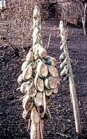 | med | large | Papaya fruit cluster in orchard of photo to left. The fruit has been cooked by radiant heat from the fountain and flow and sheared away by falling pumice. The sheared, cooked side of the fruit faces the fountain. Photograph taken on January 16 by unknown photographer. |
 | med | large| Eerie twilight view of papaya zombies at foot of high fountain. Date and photographer unknown. |
 |
Stripped coconut palms north of
fissure, with bomb craters indenting the tephra on the flank
of the new cone, Pu`u Laimana. Same coconut grove is shown in
aerial
photo. Photo by J.P. Eaton, date unknown. | med | large | |
| House belonging to the Hongo family set fire by advancing `a`a in the foreground, 1800 January 16. Note fountain behind tree near right edge of view. Photo by J.P. Eaton. |
 | med | large | |
 | med | large | |
Burning house, probably in the village of Koa`e, at front of `a`a flow. Photo taken on January 23 by unknown photographer. |
 |
Advancing front of small, thin,
fast-moving `a`a lobe into a field, early in the eruption.
Photographer unknown. | med | large | |
Early in the morning, fountains from vent B played at heights of 365-425 m high, with glowing pumice wafted over 900 m high. The main fountain waned a little and then, during daylight hours, split into two parts. One part directed lava into the outlet channel that headed northeast from the cone. The other rose through a pond of lava in the vent and tossed large quantities of lava onto the south flank of the cone--the Kapoho side. Seven successive flows fed by this lava headed toward Kapoho, but each died before reaching town when its limited supply was interrupted.
The high fountains added lava to the `a`a flows that continued to move away from the growing cone. On the morning of January 18, flows finally overtopped the north wall of the graben on either side of the road to Koa`e and started inching toward the settlement.
Fountains rose to over 335 m in the evening of the 18th, adding material to the increasingly unstable cone as well as sending large volumes out into the flows. At about midnight, the south side of the cone collapsed, and a flood of lava headed toward Kapoho. The cone repaired itself in an hour, however, and once again the town was out of immediate danger.
The `a`a continued to enter the ocean at the northeast end of the graben but was also spreading southward (see map for Jan. 23). Three valiant attempts were made to stop the flow before it could inundate Kapoho, Kapoho School, or an area of expensive homes and real estate at Kapoho Beach Lots. The initial decision was made to construct a barrier between the east end of Kapoho and the west end of Pu`u Kuki`i. This location can be questioned, for the barrier was downslope from Kapoho and 6-12 m below the natural barrier between Pu`u Kuki`i and Kapoho Crater. The barrier was started on the morning of January 19 and completed the next day, when it stood 4.5-6 m high, still below the level of the natural ridge.
 |
 |
|
Scenes of bulldozers constructing one of the barriers from Pu`u Kuki`i to Kapoho. Note the glowing rocks that the bulldozer is moving in the left image, and the advancing front of `a`a between the fountain and the trees in the right image. Date and photographer unknown. |
|
By 1530 January 20, lava had reached the east end of the barrier, and a 6-m-thick `a`a flow was approaching the barrier from the west. The barrier lasted until January 23 but eventually succumbed to the flows. Its destruction spurred hasty construction of a second dike to buy time for construction of a more massive, “last ditch” barrier on the high ground between Pu`u Kuki`i and Kapoho Crater. The second dike, built on January 23-24 (see map for Jan. 23), lasted until early on the 27th, when a thick `a`a flow unceremoniously shoved it aside.
 |
 |
 |
|
Scenes of `a`a destroying barriers between Kuki`i and Kapoho. In the left image, an `a`a flow has just reached the barrier, with Kapoho Cone in the background. In the middle image, lava is breaching a barrier near Pu`u Kuki`i. In the right image, lava is pouring over a dike and has largely destroyed it; Pu`u Kuki`i is in background. Photographers and exact dates for these images are unknown. |
||
Meanwhile, work had started on the third, “last ditch” Kuki`i-Kapoho barrier on January 25 (see map for Jan. 27). This bulldozed structure reached 450 m along the high saddle from Pu`u Kuki`i to Kapoho Crater, just northwest of Kapoho School. When finished a day or two later, the third barrier was 5 m or more high along its entire length and was the most massive of all the barriers constructed during the eruption.
The `a`a reached the third barrier at 0400 January 28 and quickly rose to a level even with the top of the dike. The flow then thickened as more lava piled against the barrier, reaching the unusually great height of 15 m above pre-eruption ground level by dawn. The resulting high pressure caused lava to inject into the uncompacted cinder in the cone of Pu`u Kuki`i. A 150-m-long piece of the cone was floated to a height of 10 m above its former position. The lava plowed underground through the cone, diving beneath the end of the barrier built on the cone and emerging just after dawn south of the barrier, near Kapoho School (see map for Jan. 30). The buildings began to burn at 1000, and the school was lost by 1230. The barrier itself remained intact, and it survived until February 5, when it was finally overtopped and almost totally buried by lava that had completely encircled Pu`u Kukae and Pu`u Kuki`i (see final map). This flow eventually covered the Kapoho cemetery.
 |
The heaved, uplifted block on the
southwest side of Pu`u Kuki`i. It was dislodged and uplifted
by lava tunneling through the cone from in front of the
third Kuki`i-Kapoho barrier. The uplift took place on January
28 and led to the destruction of Kapoho School. Photo by J.P.
Eaton at 1800 January 31. Note: the original photo is not sharp. | med | large | |
 |
`A`a just reaching one of the buildings
at Kapoho School, about 1000 January 28. Photographer unknown. | med | large | |
 |
Kapoho cemetery, at the base of Pu`u
Kuki`i, is being covered by `a`a on February 4. Photographer unknown. | med | large | |
Another barrier, this one about 1.6 km long, was constructed along a broad forested ridge from the east end of Pu`u Kukae almost to the ocean. Work began on this structure on the morning of January 21, and by late afternoon more than two dozen large caterpillar tractors were in operation. It was hoped that the barrier would prevent lava from engulfing Kapoho Beach Lots or the Coast Guard facilities at Cape Kumukahi.
The barrier held for awhile; flows piled against it but did not breach the dike. By midafternoon of January 28, however, the long barrier was broken though in four places, the largest only 250 m from the Coast Guard residences. By January 29, the barrier was no longer effective, having been overtopped or breached in many places (see map for Jan. 30). The flow teased the residence area in on-again, off-again fashion for several days, surrounding but not destroying the houses until February 2.
Meanwhile, the long barrier was also being outflanked. Lava had built into the sea beyond the end of the barrier, turned southward, and was advancing toward the Coast Guard lighthouse on January 27. Luckily this lobe of the flow stopped soon thereafter. Once the barrier was breached, lava once more threatened the lighthouse, but, as nearly every resident of Hawai`i Island knows, it stopped, almost miraculously, just short of overrunning the facility.
Lava moved still farther south after breaching the long barrier. After destroying the Coast Guard residences, the flow headed toward Kapoho Beach Lots on February 2. Kula Pond was quickly buried, and the flow advanced southward both on land and in shoal water. Six houses were destroyed during the night of February 3-4. The flow had nearly stopped at 0800 on the 4th, however, and it moved only a little farther before stagnating for good early on February 5.
 |
Incandescent a`a` flow is filling Kula Pond on February 2. Dead and jumping, dying fish are visible in the lower right part of the photo, particularly the large image. Observers reported that “the water was so hot that we could not hold our hands in it for more than a few seconds; yet, great numbers of fish, including eels, were still alive and many were swimming in the near-boiling water at the very edge of the flow. They swam frantically about with head and back above water in a futile effort to escape the steaming waters.” Quote from Richter and others (1970). Photographer unknown. |
The lava that overtopped the Koa`e fault on January 18 spread slowly northward toward the houses of Koa`e. The advance was so slow and sporadic that it looked as if the village might be spared. Day by day the lava inexorably moved closer and closer, however, finally surging forward at noon on January 23 to claim a house, community hall, and church in the next four hours. Another house was destroyed in the early evening, but the flow seemed to be stopping. One more building was overrun before the flow ceased moving on about January 28.
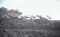
Despite notable developments in the vent area, Kapoho village remained virtually intact except for a blanket of pumice and ash that covered everything. The cinder cone grew to 72 m high by January 20, towering above the buildings of nearby Kapoho, and a neighboring steep-sided spatter cone was another 20 m higher by January 24. But the cones in themselves provided little threat to the town. The `a`a flow just north of the village had remained stagnant for several days, and if the barriers held farther east, there was hope that the town could be saved.
 |
 |
|
Aerial views across the fountains and cone at about 1600 on January 23. Photos by J.P. Eaton. Left image looks southeastward toward fountain at main vent B (left), which feeds river flowing through breach in cinder-pumice cone. Spatter cone E (right side) is higher than the main cone. Defoliated coconut grove in foreground is dwarfed by the growing 60-m-high cone. This cone complex later grew to become Pu`u Laimana. Kapoho town is the cluster of buildings just to left of top of fountain. Right image looks southwestward and shows a wide river of `a`a pouring from the downrift side of the cone at vent B. Now-defunct vents A and D are at extreme right tip of flow, just below the wing strut. Note the brown, dead vegetation near the flow, in contrast to the green fields toward top of photo. The village of Koa`e is below the field of view. Photo by J.P. Eaton, 1600 January 23. |
|
Almost diabolically, the flow resumed its advance toward Kapoho at 0100 January 27, and within ten minutes a house had been crushed by the cold clinkery part of the old, 6-m-high flow front. The flow then stopped, as if taunting the village, but revived later in the day to enter the backyards of houses on the north side of the main street.
Of even greater concern, however, was the large lava lake or flow ponded northwest of Pu`u Kuki`i. If the lava dam holding in the lake were to fail, a flood of lava might engulf the village in a few hours. Fortunately this never happened.
For seven hours on the afternoon of January 27, the heaviest pumice fall of the entire eruption rained down on the area northeast of the cone, during strong kona winds. The pumice built a long mound or loaf nearly as high as the main cone and extending 1 km downrift. Several tens of meters of pumice and cinder fallout covered the lava lake, whose northern edge was impounded by the growing pumice loaf.
 |
Fountaining vent B at 1635 February 2, looking west from
top of Pu`u Kuki`i. A large outflow lake of lava covers much
of the area. The long ridge extending northeast from the
vent is the pumice ridge or loaf that mostly formed during
the most intense pumice fall of the eruption on January 27.
Photo by J.P. Eaton. | med | large | |
Late on that fateful day, very fluid lava was pouring from vents B, L, and K and feeding the massive `a`a flows between Pu`u Kuki`i and Kapoho. This new source of lava doomed the town. At 2330 the flow was nearing the town. In the next 30 minutes, the rapidly moving`a`a flow moved southwestward through the streets, overwhelmed building after building and leaving only memories behind. By midnight January 27, most of Kapoho had been destroyed.
The coups de grâce was administered on January 30, when lava oozed from the south base of the cinder-pumice cone, reached the west end of Kapoho, and overwhelmed two more buildings.
During the night of January 30-31, fountain temperatures, measured with an optical pyrometer and therefore lower than real temperatures, were 20-50 oC higher than most earlier measured temperatures. (The temperature increase had started on January 27 but was erratic.) This coincided with a period of narrow, high fountains that lasted the day. Together with the temperature increase was a change in mineralogy that was consistent with hotter temperatures. It was later discovered that a batch of hotter magma from Kilauea’s summit had mixed with cooler magma that had been stored in a reservoir beneath the Kapoho area since 1955 or earlier.
 |
Fountain 200-300 m high above the main vent, B, at 1650
on January 31, viewed from Pu`u Kea near Kapoho.
Earlier in the day, measured fountain temperatures had
increased, and the olivine content of the lava, previously
small or absent in the dominantly plagioclase-clinopyroxene
phenocryst assemblage, jumped up. A few days later, olivine
became the dominant phenocryst. This change in temperature
and mineralogy led to interpretations of magma mixing, hot
magma derived from the summit reservoir mixing in various
proportions with magma left in the rift zone after an earlier,
probably 1955, eruption (Richter and Murata, 1966; Murata
and Richter, 1966; Wright and Fiske, 1971). Photo by J.P.
Eaton. | med | large | |
The eruption ended slowly. Dribbles of lava continued to enter the sea north of Cape Kumukahi as late as February 13. High fountains continued until February 15, when lava was spraying upward from the main vent area to heights of 300 m. But the vigor and discharge of the eruption were, in general, steadily declining until the morning of February 19, when the eruption stopped. With time, vent J took over for vent B as the main vent. The high cone complex of cinder and pumice towered more than 100 m above the landscape, eventually being christened Pu`u Laimana after the Lyman family, who owned the area.
When it was all over, lava flows covered more than 10 km2, including 2 km2 of new land beyond the original shoreline (see final map). The volume of lava erupted is conservatively estimated as 122 million cubic meters with an additional 7.5 million cubic meters of pyroclastic material. The eruption was the third largest of the 20th century at Kilauea, dwarfed only by the much longer-lasting Mauna Ulu and Pu`u `O`o-Kupaianaha eruptions. See the table of eruptions for volume comparisons.
The Kapoho eruption was tied inextricably to events at Kilauea’s distant summit. Foreshadowed by the great Kilauea Iki fountains, it was accompanied by deflation of the summit that would have been the headline of the day had not all eyes been focused on the Kapoho.
On January 17, four days after the Kapoho eruption had started, the summit began to subside (deflate, by analogy with a balloon) and tilt inward, apparently as magma was leaving the storage reservoir and heading down the east rift zone to the Kapoho area (see Kilauea map). Most of the deflation had taken place by the time the eruption ended, but it tailed off gradually until the summer. The total deflation, 350-400 microradians, is far larger than any other deflation at Kilauea since precise measurements were started in 1957. See plot of tilt. For an analysis of the deflation, see Eaton (1962).
The deflation could not be seen. The summit was going down and tilting inward precipitously, yet it took instruments to detect it. When the bottom began to drop out of Halema`uma`u crater, however, even the least observant sat up and took notice.
Small, shallow earthquakes were coming from beneath Kilauea’s summit by January 23, as rocks surrounding the emptying reservoir began to fail. By the end of the month, a seismograph on the caldera floor was recording thousands of earthquakes daily. Hundreds could be felt each day, and the swarm kept getting bigger and bigger. Old cracks around Halema`uma`u widened, and new ones formed. Rock avalanches from the walls of Halema`uma`u became common. On February 5, new steaming areas appeared in a 60-m-wide ring encircling Halema`uma`u’s 140-m-deep, 0.5-km2 floor. This brought up memories of the collapse and steam explosions at Halema`uma`u in 1924.
Collapse of Halemau`ma`u’s floor began during the night of February 6-7. The ground near Halema`uma`u was in almost constant motion throughout the night. Strange booming sounds came from the dark crater, accompanying the constant clatter of rock fall and avalanches. Observers at daybreak could see a broad saucer-shaped depression bounded by a 6-9-m scarp 30-90 m in from the wall of the crater. Unseen cracks had apparently opened beneath the 90-m-deep lava lake erupted in 1952, and liquid lava still in its core was draining away. See cross sections through Halema`uma`u
Slowly the depression deepened to about 30 m, watched and measured by HVO and National Park personnel. Then, starting at 1151, a circular area 300 m in diameter in the central part of the depression suddenly began to drop at terrifying speed. The resulting pit collapsed more than 60 m in just 9 minutes. At noon, viscous lava began to pour from a ring fracture into the pit. The lava was coming from the 1952 lake. Throughout the afternoon of the 7th and all day on the 8th, this lava accumulated in a pond 20 m deep in the pit. Lava extrusion continued slowly and intermittently through February 11.
A second collapse pit formed late in the afternoon of February 9 southwest of the main pit. It developed in about 10 minutes and did not intersect any still-liquid lava.
 The main collapse pit in Halema`uma`u during the afternoon of February 7, looking north from the observation platform on the south rim of the crater. Lava stored in the lake created in 1952 is draining from a ring fracture and filling the pit, which is about 300 m in diameter. Photo by J.P. Eaton. |
 Looking southwestward across Halema`uma`u in March 1960, after the collapse had ended. The saucer-shaped subsidence of the floor is evident, as is the central collapse pit, now partly filled with lava of 1952 vintage. The second, southwest, collapse pit is in the right-central part of the photo, at the base of a large talus pile nestled against the wall. Photographer unknown. |
On February 12, a large earthquake shook the summit, caused the Hilina Pali Road to be offset 15 cm vertically at the crossing of Kulanaokuaiki Pali 7 km south of Halema`uma`u, and opened many cracks in the adjacent part of the Koa`e fault system (the summit Koa`e, not the Kapoho one). On March 7, a shallow earthquake caused minor damage to residences in the Park and Volcano.
On March 11, the third and final collapse of the floor of Halema`uma`u took place. In about 25 minutes, a pit 90 m by 120 m in diameter and 30 m deep formed in the northeast part of the remaining uncollapsed floor left from the 1954 eruption. At night, the lower wall of the new pit was incandescent. This was the last major event associated with the 1959-60 eruption. See map for the final configuration of the crater floor.
The total volume of collapse in Halema`uma`u was about 22 million cubic meters, about half of that which erupted to form the lava lake in 1952.
And so the calamitous 1959-60 eruption of Kilauea came to an end. It provided wondrous sights, heartbreaking losses, and terrifying moments. The eruption was the first during the modern era of volcano monitoring at HVO. As a result, probably more fundamental ideas were reached from it than from any other single eruption in Hawai`i. It is also the earliest eruption remembered by many current residents of the island. With time, these residents will pass away, and the glorious and tragic events of November 1959 to March 1960 will be lost except in photographs and writings.
The main lesson, and really the only one that bears repeating over and over again, is clear. What happened then will happen again. That lesson should never be lost.
Eaton, J.P., 1962, Crustal structure and volcanism in Hawaii, in Macdonald, G.A., and Kuno, Hisashi, eds., The Crust of the Pacific Basin: American Geophysical Uhion Geophysical Monograph 6, p. 13-29. (This is the first major interpretation of the deflation of Kilauea’s summit during the Kapoho eruption.)
Eaton, J.P., and Murata, K.J., 1960, How volcanoes grow: Science, v. 132, n. 3432, p. 925-938. (A classic paper that sets out the model for Hawaiian eruptions that forms the basis for today’s interpretations. The paper is based largely on observations and data obtained during the Kilauea Iki and Kapoho eruptions.)
Murata, K.J., and Richter, D.H., 1966, Chemistry of the lavas of the 1959-60 eruption of Kilauea volcano, Hawaii. U.S. Geological Survey Professional Paper 537-A, 26 p. (The first analysis of the chemical changes during the eruption.)
Richter, D.H., Eaton, J.P., Murata, K.J., Ault, W.U., and Krivoy, H.L., 1970, Chronological narrative of the 1959-60 eruption of Kilauea Volcano, Hawaii: U.S. Geological Survey Professional Paper 537-E, 73 p. (This is the Bible of the eruption. All ideas and many of the words used above have come from this classic description of the Kilauea Iki and Kapoho eruptions.)
Richter, D.H., and Murata, K.J., 1966, Petrography of the lavas of the 1959-60 eruption of Kilauea volcano, Hawaii: U.S. Geological Survey Professional Paper 537-D, 12 p. (Documents the mineralogical changes during the eruption.)
Wright, T.L., and Fiske, R.S., 1971, Origin of the differentiated and hybrid lavas of Kilauea volcano, Hawaii: Journal of Petrology, v. 12, p. 1-65. (This paper presents the first mixing model for the eruption.)
![]()
![]()
![]()
![]()
![]()
![]()
![]()
![]()
![]()
![]()