ACIS - A Climate-Data Management Solution
About ACIS
Why is ACIS Unique?
The ACIS Design Concept
Benefits of using ACIS
The ACIS System
MetaData
Climate Data
Data Ingest & Archive
Quality Control
Climate Products
User Interfaces
Visual Products
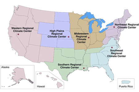
There are 6 Regional Climate Centers offering climate services in the U.S. Click on the map to go directly to the center serving your area.
State and Federal Agencies use ACIS to Enhance their operations
- NWS: NOWData, xmACIS
- NRCS: Custom interface and products
- USDA/JAWF: Data for mapping
- University of Washington: Uses ACIS data for near real-time soil moisture model
- State Climatologists: Web pages in the following states use ACIS data - LA, MS, OK, DE, PA, CA, NV, IL
ACIS Highlights
- Download the ACIS brochure
- BAMS Announcement
- ACIS Current Climate Summary Maps
- 2003 ACIS Power Point Presentation
CLIMOD Servers
ACIS VISION
ACIS is a fully functional system with a flexible design. ACIS will evolve to incorporate additional data sources, generate new and improved data products, take advantage of emerging technologies, and respond to the needs of its users.
![]()

![]() http://rcc-acis.org is hosted by the High Plains Regional Climate Center
http://rcc-acis.org is hosted by the High Plains Regional Climate Center
HPRCC supports a three-tiered national climate services support program.
The partners include: National Climatic Data Center, Regional Climate Centers, and State Climate Offices.
Contact
© 2009 NOAA Regional Climate Centers