
USGS Drought Watch

 For information on drought and water resources throughout the United States, please visit WaterWatch For information on drought and water resources throughout the United States, please visit WaterWatch | |
 For comprehensive information on emerging and ongoing droughts, visit the National Integrated Drought Information System page For comprehensive information on emerging and ongoing droughts, visit the National Integrated Drought Information System page
|
|
Latest Water Conditions

February 2009: USGS MD-DE-DC Water Conditions Summary
Current streamflow information maps based on readings from streamflow gages in the MD-DE-DC Water Science Center.

Current ground-water information maps are listed by county, categorized by water table or confined aquifer, with 5 year information. This information is based on monthly readings from selected wells in the MD-DE-DC Water Science Center.
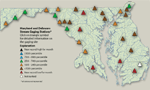
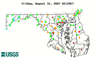
Daliy Streamflow for Maryland and Delaware


The real-time data used to produce this map are provisional and have not been reviewed or edited. They may be subject to significant change. The map depicts streamflow conditions as measured at USGS gaging stations. The colors represent discharge as a percentile, which is computed from the period of record for the current day of the year. Only stations having at least 30 years of record are used.
Active real-time stations having more than 30 years of continuous record are shown as colored circles. Uncolored circles depict stations having less than 30 years of record, or that are currently not transmitting.
Note: Hold down the Shift key and click on Reload or Refresh to make sure you have the most recent image or table.
Daily Streamflow Conditions for the Middle Atlantic Region
Streamflow and Ground-Water Conditions from the U.S. Geological Survey
- Conditions in Maryland, Delaware, and D.C.
- Current Streamflow

- Ground Water Conditions and Information
- Seasonal Streamflow Conditions and Historic Droughts
- Monthly Water Conditions Reports, including:
- Conditions in nearby states and across the United States:
-
Note: USGS water information for any state can be obtained at:
xx.water.usgs.gov,
where xx is the U.S. Postal Service abbreviation.
- Drought Photographs
- 1999 drought photographs from the USGS
- 2002 drought photographs from the USGS
Links and More Information
Drought Resources
- US Drought Monitor
- Middle Atlantic River Forecast Center Precipitation Departure Map
- Drought Information from Regional and Federal Agencies
- MDE Drought Information Page
- Maryland Climate Response Network
- Water Conservation
- Water Conservation Tips from the Department of Agriculture
Articles and News (2007)
- Drought killing corn crop early this year, affecting livestock
- Drought emergency is in Maryland's future
- Voluntary water ban proposed
- Dire Forecast For Md., Va. Corn Crops
- Anne Arundel officially in drought
- Drought Conditions Affecting Md. Food Supply
- Drought Parches Most Of Maryland
- No relief in sight from Washington-area drought
- St. Mary's Pulls Plug on Water Use
- Maryland Forest Service Urges Caution To Avoid Wildfires
- Lack of rain, gypsy moths stress trees
- Drought Diminishing Hay Supply For Cattle
- Drought Affects Eastern Shore Wells
- Withered D.C. Region Cries for Water, Cool Water
- Wells under pressure during drought
- Westminster Orders Water Restrictions
- Maryland drought creeps north
- Pests and Drought Damage Trees
- Drought Problems Continue For Maryland
- DNR Urges Caution During Outdoor Activities To Prevent Wildfires
- Rain At Last, But Drought Persists

