
- Home
- About S&T
- Taxa/Organisms
- Ecosystems
- Issues
- Methods & Tools
- Reports & Publications
- Location
- Search
Publisher: USGS | Science Center: Forest and Rangeland Ecosystem Science Center (FRESC, Corvallis) | Format: URL
sagemap.wr.usgs.gov — SAGEMAP - Spatial Data for Sage Grouse and Shrubsteppe Systems is needed for research and management of sage grouse and sagebrush steppe habitats in the western United States. This website is a product of the NBII Great Basin Information Project. Find out more from this resource on sage grouse as endangered species, habitat information, More...

Publisher: USGS | Science Center: Upper Midwest Environmental Sciences Center (UMESC, LaCrosse) | Format: URL
www.umesc.usgs.gov — This web resource provides decision makers with the information needed to maintain the Upper Mississippi River System as a viable multiple-use large river ecosystem. This resource also includes Data and sampling information, publication links, reports, other related documents and statistics, as well as links to field stations and other projects More...
Publisher: USGS | Science Center: Upper Midwest Environmental Sciences Center (UMESC, LaCrosse) | Format: URL
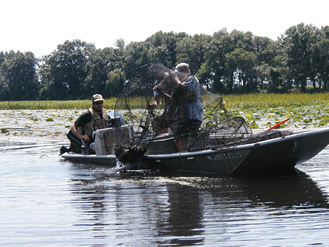
www.umesc.usgs.gov — Presently, the Long Term Resource Monitoring Program (LTRMP) conducts annual monitoring of vegetation using a stratified random sampling method (Yin et al. 2000) in five study reaches of the Upper Mississippi River System: Navigation Pools 4, 8, 13, and 26 on the Mississippi River; and La Grange Pool on the Illinois River. The LTRMP will continue More...

Publisher: USGS | Science Center: Western Ecological Research Center (WERC, Sacramento) | Format: URL
www.werc.usgs.gov — Invasion and subsequent restructuring of ecosystems by nonnative organisms is taking on increasingly urgent significance as an example of human-caused environmental change with potentially dramatic consequences. This web resource discusses the affects of vascular plants - particularly in Sequoia, Kings Canyon, and Yosemite National Parks - on the More...
Publisher: USGS | Science Center: Western Ecological Research Center (WERC, Sacramento) | Format: URL
www.werc.usgs.gov — Pinon-juniper woodlands have expanded beyond their historical range in the western United States, due partly to land management practices such as fire suppression that began with settlements of the region in the late 1880s. This woodland expansion has replaced sagebrush steppe vegetation, leading to decreased wildlife habitat, soil seedbanks, and More...
Publisher: USGS | Science Center: Western Ecological Research Center (WERC, Sacramento) | Format: URL
www.werc.usgs.gov — This issue overview focuses on nonnative grass invasions and fire in the Mojave Desert, which appear to have been infrequent historically. When fires occurred, gaps of plant-free space separating individual shrubs, bunchgrasses, cacti, and trees, stopped the spread of fires like networks of small firebreaks. The increasing dominance of nonnative More...

Publisher: USGS | Science Center: Southwest Biological Science Center (SBSC, Flagstaff) | Format: URL
sbsc.wr.usgs.gov — From the website: "The Southwest Exotic Plant Information Clearinghouse is a cooperative effort among the U.S. Geological Survey, the National Park Service and Northern Arizona University to organize comprehensive information on exotic plant species in the southwest on one web location. SWEPIC serves to help all people and organizations committed More...
Publisher: USGS | Science Center: Upper Midwest Environmental Sciences Center (UMESC, LaCrosse) | Format: URL
www.umesc.usgs.gov — After a series of navigation dams were constructed in the Upper Mississippi and Illinois Rivers in the 1930s, aquatic vegetation flourished. Its distribution, however, has fluctuated drastically in the 1980s and 1990s. As the navigation system ages, the fate of this important ecosystem component is a growing concern. This issue overview's More...

Publisher: USGS | Science Center: Upper Midwest Environmental Sciences Center (UMESC, LaCrosse) | Format: URL
www.umesc.usgs.gov — The diversity of habitat types, plants, and animals in the Upper Mississippi River has declined considerably over the last 50 years, creating loss of aquatic vegetation, loss of islands and side channels behind dams, and changes in river sediments, potentially caused by the method of managing water levels, which maintains artificially high water More...

Publisher: California Information Node | Format: URL
cain.nbii.gov — The California Information Node provides access to data and information about California's environment. Among the topics covered are: invasive species, resource management, conservation, restoration, plants, animals, watersheds and policies. Images, maps and spatial data are also provided. Links to biological issues, biological disciplines, More...

Publisher: NBII | Format: URL
www.nbii.gov — Natural resource managers face complex decisions that require a clear understanding of the status of wildlife populations and their habitats. Monitoring is key to making effective management decisions and evaluating the outcomes of those decisions. The goal of NRMP is to improve the accessibility of monitoring efforts to resource managers to aid More...
Publisher: USGS | Science Center: Fort Collins Science Center (FORT, Ft. Collins) | Format: URL
www.fort.usgs.gov — Natural Resource Monitoring Partnership (NRMP) is a collaborative effort by the natural resource management community to improve monitoring efforts in order to support effective evaluation and decision-making by sharing information on monitoring projects and protocols. The Natural Resource Monitoring Partnership was built for easy access to More...
