
 Feeds & Data
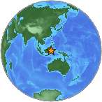
Magnitude 7.3 - MINAHASA, SULAWESI, INDONESIA
2008 November 16 17:02:32 UTC
Earthquake Details
| Magnitude | 7.3 |
|---|---|
| Date-Time |
|
| Location | 1.290°N, 122.100°E |
| Depth | 30 km (18.6 miles) set by location program |
| Region | MINAHASA, SULAWESI, INDONESIA |
| Distances | 135 km (85 miles) NW of Gorontalo, Sulawesi, Indonesia 310 km (190 miles) W of Manado, Sulawesi, Indonesia 1485 km (920 miles) S of MANILA, Philippines 1890 km (1170 miles) ENE of JAKARTA, Java, Indonesia |
| Location Uncertainty | horizontal +/- 5.1 km (3.2 miles); depth fixed by location program |
| Parameters | NST=321, Nph=321, Dmin=744.3 km, Rmss=1.1 sec, Gp= 32°, M-type=regional moment magnitude (Mw), Version=U |
| Source |
|
| Event ID | us2008zlbn |
- This event has been reviewed by a seismologist.
- Did you feel it? Report shaking and damage at your location. You can also view a map displaying accumulated data from your report and others.
Earthquake Summary

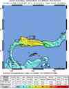
Felt Reports
At least six people killed, 77 injured, 10,000 people displaced, 1,000 buildings damaged and communications disrupted in the Buol area and in Gorontalo. Felt (VII) at Baolan; (VI) at Gorontalo and Tolitoli; (IV) at Manado and Poso; (III) at Luwuk. Also felt (IV) at Bandar Seri Begawan, Brunei and (II) at Darwin, Australia. Felt at Kolaka, Kuta, Makasar, Palu and Ujung Bulu, Indonesia; Kunak and Sandakan, Malaysia; General Santos and Koronadal, Philippines.
Tectonic Summary
The magnitude 7.3 Sulawesi, Indonesia earthquake of November 16, 2008 occurred as a result of thrust faulting on a plate-boundary that is marked by the North Sulawesi trench, separating the Celebes Sea basin and the Minahassa peninsula. Eastern Indonesia is characterized by complex tectonics in which motions of numerous small plates are accommodating large-scale convergence between the Australia and Eurasia plates. At the location of today's earthquake, the Celebes Sea basin (commonly considered part of the Sunda plate) moves south with respect to the Minahassa peninsula (part of the Molucca Sea plate) at a velocity of about 30 mm/year. The lithosphere of the Celebes Sea basin is thrust beneath that of the Minahassa peninsula and is seismically active to a depth of about 250 km.
The earthquake occurred approximately 25 km off the northern coast of the Minahassa peninsula of the Island of Sulawesi in an area that has seen large earthquakes in the past. For example, a damaging magnitude 7.6 earthquake occurred on April 18, 1990 approximately 85 km east of today's earthquake. The magnitude 7.6 earthquake in 1990 was followed a year later by a magnitude 7.5 earthquake in approximately the same place. More recently a magnitude 7.0 occurred within 45 km of today's earthquake on November 25, 1997. The 1997 earthquake caused damage to at least 90 building in the Gorontalo area of northern Sulawesi.
Earthquake Information for Asia
Earthquake Information for Indonesia
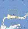
 Tsunami Information
- NOAA West Coast & Alaska Tsunami Warning Center
- NOAA Pacific Tsunami Warning Center
- Tsunami Information Links
The earthquake locations and magnitudes cited in these NOAA tsunami bulletins are very preliminary and may be superceded by USGS locations and magnitudes computed using more extensive data sets.
Earthquake Maps


Scientific & Technical Information

- Preliminary Earthquake Report
- U.S. Geological Survey, National Earthquake Information Center:
World Data Center for Seismology, Denver
