
 Feeds & Data
Magnitude 6.6 - QUEEN CHARLOTTE ISLANDS REGION
2008 January 05 11:01:05 UTC
Earthquake Details
| Magnitude | 6.6 |
|---|---|
| Date-Time |
|
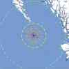
| Location | 51.276°N, 130.750°W |
| Depth | 10 km (6.2 miles) set by location program |
| Region | QUEEN CHARLOTTE ISLANDS REGION |
| Distances |
|
| Location Uncertainty | horizontal +/- 4.4 km (2.7 miles); depth fixed by location program |
| Parameters | NST=264, Nph=264, Dmin=493 km, Rmss=1 sec, Gp= 68°, M-type=moment magnitude (Mw), Version=8 |
| Source |
|
| Event ID | us2008lvaw |
- This event has been reviewed by a seismologist.
- Did you feel it? Report shaking and damage at your location. You can also view a map displaying accumulated data from your report and others.
Earthquake Summary


The following is a release by the United States Geological Survey, National Earthquake Information Center: An earthquake occurred 200 km (125 miles) WSW of Bella Bella, British Columbia, Canada, 240 km (150 miles) WNW of Port Hardy, British Columbia, Canada, 585 km (365 miles) WNW of Vancouver, British Columbia, Canada, 620 km (385 miles) NW of VICTORIA, British Columbia, Canada at 4:01 AM MST, Jan 5, 2008 (3:01 AM PST in Canada). The magnitude and location may be revised when additional data and further analysis results are available. There have been no reports of damage. Additional information about this earthquake can be obtained from the Geological Survey of Canada in Sidney, British Columbia (604-363-6500).
Felt Reports
Felt (III) at Port Hardy, Sandspit and Skidegate, British Columbia. Also felt at Winter Harbour.
Earthquake Maps


Scientific & Technical Information

Additional Information, News Reports
- Preliminary Earthquake Report
- U.S. Geological Survey, National Earthquake Information Center:
World Data Center for Seismology, Denver
