
 Feeds & Data
Magnitude 4.8 - SOUTHERN ALASKA
2006 July 27 13:18:01 UTC
Earthquake Details
| Magnitude | 4.8 |
|---|---|
| Date-Time |
|
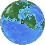
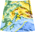
| Location | 61.168°N, 149.668°W |
| Depth | 34.2 km (21.3 miles) |
| Region | SOUTHERN ALASKA |
| Distances |
|
| Location Uncertainty | horizontal +/- 1.6 km (1.0 miles); depth +/- 1.1 km (0.7 miles) |
| Parameters | NST=021, Nph=025, Dmin=9.4 km, Rmss=0.87 sec, Gp= 68°, M-type=local magnitude (ML), Version=6 |
| Source | |
| Event ID | ak00067294 |
- This event has been reviewed by a seismologist.
- Did you feel it? Report shaking and damage at your location. You can also view a map displaying accumulated data from your report and others.
Earthquake Summary
Felt Reports
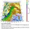
Felt (IV) at Anchorage, Chugiak, Eagle River, Elmendorf AFB, Girdwood, Indian, Palme, Seward and Talkeetna; (III) at Fort Richardson, Kenai, Moose Pass, Pilot Station, Wasilla and Willow; (II) at Homer and Valdez. Also felt at Cooper Landing, Glennallen, Kasilof, Soldotna, Sterling and Tok.
Earthquake Maps


Scientific & Technical Information
 Historic Moment Tensor Solutions
- Preliminary Earthquake Report
- Alaska Earthquake Information Center
Geophysical Institute, University of Alaska Fairbanks
