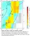
Magnitude 7.2 - NEAR THE EAST COAST OF HONSHU, JAPAN - usbvae
2005 August 16 02:46:28 UTC
A major earthquake occurred at 02:46:28 (UTC) on Tuesday, August 16, 2005.
The magnitude 7.2 event has been located in NEAR THE EAST COAST OF HONSHU, JAPAN.
(This event has been reviewed by a seismologist.)
Earthquake Summary
Felt Reports
At least 39 people injured in Miyagi, 9 in Iwate, 5 in Fukushima and 3 in Saitama Prefectures. A house collapsed at Kazo. Landslides occurred in several rural locations. Power outages occurred and bullet train service was temporarily suspended in northern Japan. A local tsunami was generated with a wave height of 10 cm on the coast of northern Japan. Felt (VI) at Sendai, (V) at Misawa and (IV) at Tokyo. Recorded (6L JMA) in Miyagi and Yamagata; (5U JMA) in Fukushima and Iwate; (5L JMA) in Akita, Aomori, Ibaraki and Tochigi; (4 JMA) in Chiba, Gumma, Kanagawa, Nagano, Niigata, Saitama, Shizuoka, Tokyo and Yamanashi; (3 JMA) in Aichi, Gifu and Mie; (2 JMA) in Fukui, Ishikawa, Shiga and Toyama Prefectures. Recorded (2 JMA) on Kozu-shima, Miyake-jima, Nii-jima, O-shima and Sado-shima; (1 JMA) on Aoga-shima, Hachijo-jima and Mikura-jima. Also recorded (3 JMA) in southwestern Hokkaido and in the Chitose-Ebetsu-Shizunai and Obihiro areas, Hokkaido; (2 JMA) in much of central, south- central and eastern Hokkaido. Broadband depth equal to 36.0 km.
Earthquake Information for ASIA
Earthquake Information for JAPAN
Earthquake Details
| Magnitude |
7.2 |
| Date-Time |
Tuesday, August 16, 2005 at 02:46:28 (UTC)
= Coordinated Universal Time
Tuesday, August 16, 2005 at 11:46:28 AM
= local time at epicenter
Time of Earthquake in other Time Zones
|
| Location |
38.251°N, 142.059°E |
| Depth |
36 km (22.4 miles) set by location program |
| Region |
NEAR THE EAST COAST OF HONSHU, JAPAN |
| Distances |
105 km (65 miles) E of Sendai, Honshu, Japan
150 km (95 miles) ENE of Fukushima, Honshu, Japan
165 km (105 miles) NE of Iwaki, Honshu, Japan
355 km (220 miles) NE of TOKYO, Japan
|
| Location Uncertainty |
horizontal +/- 3.9 km (2.4 miles); depth fixed by location program |
| Parameters |
Nst=271, Nph=271, Dmin=390.3 km, Rmss=0.83 sec, Gp= 29°,
M-type=teleseismic moment magnitude (Mw), Version=7
|
| Source |
USGS NEIC (WDCS-D)
|
| Event ID |
usbvae |
Earthquake Maps

Earthquake Location
Scientific & Technical Info
Additional Information, News Reports
- Preliminary Earthquake Report
- U.S. Geological Survey, National Earthquake Information Center
World Data Center for Seismology, Denver

 Feeds & Data