
 Feeds & Data
Magnitude 6.4 - COSTA RICA
2004 November 20 08:07:21 UTC
Earthquake Details
| Magnitude | 6.4 |
|---|---|
| Date-Time |
= Coordinated Universal Time = local time at epicenter |
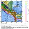
| Location | 9.602°N, 84.172°W |
| Depth | 16 km (9.9 miles) set by location program |
| Region | COSTA RICA |
| Distances |
40 km (25 miles) SSW of SAN JOSE, Costa Rica 80 km (50 miles) ESE of Puntarenas, Costa Rica 140 km (85 miles) WSW of Limon, Costa Rica 155 km (95 miles) NW of Golfito, Costa Rica |
| Location Uncertainty | horizontal +/- 3.6 km; depth fixed by location program |
| Parameters | Nst=514, Nph=514, Dmin=113.3 km, Rmss=0.90 sec, Gp= 31°, M-type=teleseismic moment magnitude (Mw) |
| Source | USGS NEIC (WDCS-D) |
| Event ID | usrban |
- This event has been reviewed by a seismologist.
Did you feel it?
Report shaking and damage at your location. You can also view a map displaying accumulated data from your report and others.
Earthquake Maps

Earthquake Location

Location Maps

ShakeMap
Historical Seismicity

Google Map
Did you feel it?
Report shaking and damage at your location. You can also view a map displaying accumulated data from your report and others.
- Preliminary Earthquake Report
- U.S. Geological Survey, National Earthquake Information Center
World Data Center for Seismology, Denver
