
 Feeds & Data
Magnitude 3.7 - EASTERN KENTUCKY
2004 September 17 15:21:43 UTC
Earthquake Details
| Magnitude | 3.7 |
|---|---|
| Date-Time |
= Coordinated Universal Time = local time at epicenter |
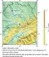
| Location | 36.932°N, 84.006°W |
| Depth | 1.2 km (~0.7 mile) set by location program |
| Region | EASTERN KENTUCKY |
| Distances | |
| Location Uncertainty | Error estimate not available |
| Parameters | Nst= 43, Nph= 43, Dmin=171.2 km, Rmss=0 sec, Gp= 58°, M-type="Nuttli" surface wave magnitude (MLg), Version=Q |
| Source | USGS NEIC (WDCS-D) |
| Event ID | usnmar |
- This event has been reviewed by a seismologist.
Did you feel it?
Report shaking and damage at your location. You can also view a map displaying accumulated data from your report and others.
Earthquake Maps

Earthquake Location

Location Maps
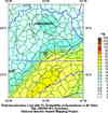
Historical Seismicity
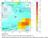
Seismic Hazard Map
EQ Density Map

Google Map
Did you feel it?
Report shaking and damage at your location. You can also view a map displaying accumulated data from your report and others.
- Preliminary Earthquake Report
- U.S. Geological Survey, National Earthquake Information Center
World Data Center for Seismology, Denver
