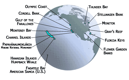
Visiting the SanctuariesIn 1972, exactly one hundred years after the first national park was created, the nation made a similar commitment to preserving its marine treasures by establishing the National Marine Sanctuary Program. Since then, thirteen national marine sanctuaries and one marine national monument, representing a wide variety of ocean environments, have been established.
Today, our marine sanctuary system encompass deep ocean gardens, nearshore coral reefs, whale migration corridors, deep sea canyons, and even underwater archeological sites. The sites range in size from one-quarter square mile in Fagatele Bay, American Samoa to more than 135,000 square miles in the Northwestern Hawaiian Islands, the largest marine protected area in the world. To learn more about a specific sanctuary site, click its name on the map above and explore their web sites. To read about the sanctuary's regions, click the region links in the navigation bar.
|