
 Feeds & Data
Magnitude 4.7 - MYANMAR
2009 May 05 09:22:51 UTC
Earthquake Details
| Magnitude | 4.7 |
|---|---|
| Date-Time |
|
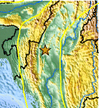
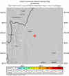
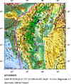
| Location | 23.353°N, 94.659°E |
| Depth | 10 km (6.2 miles) set by location program |
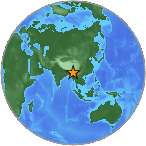
| Region | MYANMAR |
| Distances | 145 km (90 miles) NNW of Monywa, Myanmar 175 km (110 miles) SSE of Imphal, Manipur, India 650 km (405 miles) E of Kolkata (Calcutta), West Bengal, India 745 km (460 miles) NNW of YANGON (Rangoon), Myanmar |
| Location Uncertainty | horizontal +/- 37.5 km (23.3 miles); depth fixed by location program |
| Parameters | NST= 12, Nph= 12, Dmin=671.6 km, Rmss=1.19 sec, Gp=158°, M-type=body wave magnitude (Mb), Version=7 |
| Source |
|
| Event ID | us2009ggaz |
- This event has been reviewed by a seismologist.
- Did you feel it? Report shaking and damage at your location. You can also view a map displaying accumulated data from your report and others.
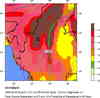
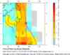
Earthquake Maps

Scientific & Technical Information
 Historic Moment Tensor Solutions
- Preliminary Earthquake Report
- U.S. Geological Survey, National Earthquake Information Center:
World Data Center for Seismology, Denver
