
 Feeds & Data
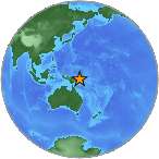
Magnitude 4.7 - NEW BRITAIN REGION, PAPUA NEW GUINEA
2009 May 05 10:28:59 UTC
Earthquake Details
| Magnitude | 4.7 |
|---|---|
| Date-Time |
|
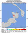
| Location | 4.633°S, 151.798°E |
| Depth | 155.9 km (96.9 miles) |
| Region | NEW BRITAIN REGION, PAPUA NEW GUINEA |
| Distances | 65 km (40 miles) SW of Rabaul, New Britain, PNG 140 km (85 miles) W of Taron, New Ireland, PNG 735 km (455 miles) NE of PORT MORESBY, Papua New Guinea 2535 km (1570 miles) N of BRISBANE, Queensland, Australia |
| Location Uncertainty | horizontal +/- 11.5 km (7.1 miles); depth +/- 18.6 km (11.6 miles) |
| Parameters | NST= 41, Nph= 41, Dmin=735.7 km, Rmss=0.97 sec, Gp= 68°, M-type=body wave magnitude (Mb), Version=7 |
| Source |
|
| Event ID | us2009gga2 |
- This event has been reviewed by a seismologist.
- Did you feel it? Report shaking and damage at your location. You can also view a map displaying accumulated data from your report and others.

Earthquake Maps


Scientific & Technical Information
 Historic Moment Tensor Solutions
- Preliminary Earthquake Report
- U.S. Geological Survey, National Earthquake Information Center:
World Data Center for Seismology, Denver
