
 Feeds & Data
Magnitude 4.9 - SOUTHERN KERGUELEN PLATEAU
2009 May 04 13:20:04 UTC
Earthquake Details
| Magnitude | 4.9 |
|---|---|
| Date-Time |
|
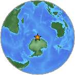
| Location | 65.202°S, 81.049°E |
| Depth | 1.9 km (1.2 miles) (poorly constrained) |
| Region | SOUTHERN KERGUELEN PLATEAU |
| Distances | 565 km (350 miles) W of Mirnyy Station, Antarctica 855 km (530 miles) E of Mawson Station, Antarctica 2775 km (1720 miles) N of South Pole, Antarctica |
| Location Uncertainty | horizontal +/- 13.6 km (8.5 miles); depth +/- 31.9 km (19.8 miles) |
| Parameters | NST= 51, Nph= 51, Dmin=>999 km, Rmss=0.87 sec, Gp= 83°, M-type=body wave magnitude (Mb), Version=Q |
| Source |
|
| Event ID | us2009gfaz |
- This event has been reviewed by a seismologist.
- Did you feel it? Report shaking and damage at your location. You can also view a map displaying accumulated data from your report and others.
Earthquake Maps
Earthquake Location
Location Maps
Historical Seismicity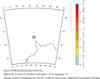
EQ Density Map
Google Map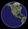
Google Earth KML
(Requires Google Earth)- Did you feel it? Report shaking and damage at your location. You can also view a map displaying accumulated data from your report and others.
Scientific & Technical Information
- Preliminary Earthquake Report
- U.S. Geological Survey, National Earthquake Information Center:
World Data Center for Seismology, Denver
