
 Feeds & Data
Magnitude 4.4 - KURIL ISLANDS
2009 May 02 18:41:03 UTC
Earthquake Details
| Magnitude | 4.4 |
|---|---|
| Date-Time |
|
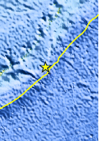
| Location | 46.321°N, 153.676°E |
| Depth | 66.9 km (41.6 miles) |
| Region | KURIL ISLANDS |
| Distances | 465 km (290 miles) ENE of Kuril'sk, Kuril Islands 520 km (320 miles) SSW of Severo-Kuril'sk, Kuril Islands, Russia 1665 km (1030 miles) NE of TOKYO, Japan 7230 km (4490 miles) NE of MOSCOW, Russia |
| Location Uncertainty | horizontal +/- 21.7 km (13.5 miles); depth +/- 17.5 km (10.9 miles) |
| Parameters | NST= 30, Nph= 30, Dmin=810 km, Rmss=1.36 sec, Gp=133°, M-type=body wave magnitude (Mb), Version=Q |
| Source |
|
| Event ID | us2009gdbc |
- This event has been reviewed by a seismologist.
- Did you feel it? Report shaking and damage at your location. You can also view a map displaying accumulated data from your report and others.

Earthquake Maps


Scientific & Technical Information
 Historic Moment Tensor Solutions
- Preliminary Earthquake Report
- U.S. Geological Survey, National Earthquake Information Center:
World Data Center for Seismology, Denver
