
 Feeds & Data
Magnitude 4.4 - NEAR THE NORTH COAST OF PAPUA, INDONESIA
2009 May 01 18:56:30 UTC
Earthquake Details
| Magnitude | 4.4 |
|---|---|
| Date-Time |
|
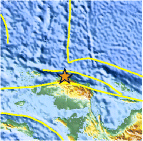
| Location | 0.374°S, 132.612°E |
| Depth | 7.9 km (4.9 miles) (poorly constrained) |
| Region | NEAR THE NORTH COAST OF PAPUA, INDONESIA |
| Distances | 155 km (95 miles) ENE of Sorong, Papua, Indonesia 175 km (105 miles) WNW of Manokwari, Papua, Indonesia 1350 km (840 miles) N of DARWIN, Northern Territory, Australia 2940 km (1830 miles) ENE of JAKARTA, Java, Indonesia |
| Location Uncertainty | horizontal +/- 14.4 km (8.9 miles); depth +/- 59.6 km (37.0 miles) |
| Parameters | NST= 23, Nph= 23, Dmin=>999 km, Rmss=0.89 sec, Gp=151°, M-type=body wave magnitude (Mb), Version=Q |
| Source |
|
| Event ID | us2009gccm |
- This event has been reviewed by a seismologist.
- Did you feel it? Report shaking and damage at your location. You can also view a map displaying accumulated data from your report and others.

Earthquake Maps


Scientific & Technical Information
 Historic Moment Tensor Solutions
- Preliminary Earthquake Report
- U.S. Geological Survey, National Earthquake Information Center:
World Data Center for Seismology, Denver
