
 Feeds & Data
Magnitude 4.6 - BANDA SEA
2009 May 01 19:04:42 UTC
Earthquake Details
| Magnitude | 4.6 |
|---|---|
| Date-Time |
|
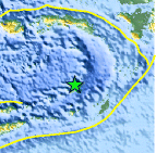
| Location | 6.484°S, 129.853°E |
| Depth | 102 km (63.4 miles) |
| Region | BANDA SEA |
| Distances | 235 km (145 miles) NW of Saumlaki, Tanimbar Islands, Indonesia 360 km (225 miles) SSE of Ambon, Moluccas, Indonesia 670 km (415 miles) N of DARWIN, Northern Territory, Australia 2550 km (1590 miles) E of JAKARTA, Java, Indonesia |
| Location Uncertainty | horizontal +/- 17.5 km (10.9 miles); depth +/- 38 km (23.6 miles) |
| Parameters | NST= 26, Nph= 26, Dmin=>999 km, Rmss=1.1 sec, Gp=122°, M-type=body wave magnitude (Mb), Version=Q |
| Source |
|
| Event ID | us2009gcbw |
- This event has been reviewed by a seismologist.
- Did you feel it? Report shaking and damage at your location. You can also view a map displaying accumulated data from your report and others.

Earthquake Maps


Scientific & Technical Information
 Historic Moment Tensor Solutions
- Preliminary Earthquake Report
- U.S. Geological Survey, National Earthquake Information Center:
World Data Center for Seismology, Denver
