
 Feeds & Data
Magnitude 4.1 - COOK STRAIT, NEW ZEALAND
2009 May 01 05:16:14 UTC
Earthquake Details
| Magnitude | 4.1 |
|---|---|
| Date-Time |
|
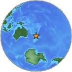
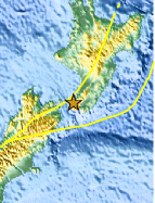
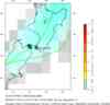
| Location | 41.193°S, 174.810°E |
| Depth | 30.4 km (18.9 miles) set by location program |
| Region | COOK STRAIT, NEW ZEALAND |
| Distances | 10 km (5 miles) NNE of WELLINGTON, New Zealand 115 km (70 miles) SW of Palmerston North, New Zealand 245 km (150 miles) SSE of New Plymouth, New Zealand 265 km (165 miles) SW of Napier, New Zealand |
| Location Uncertainty | Error estimate not available |
| Parameters | NST= 5, Nph= 5, Dmin=16 km, Rmss=0 sec, Gp=184°, M-type=local magnitude (ML), Version=S |
| Source |
|
| Event ID | us2009gcaj |
- This event has been reviewed by a seismologist.
- Did you feel it? Report shaking and damage at your location. You can also view a map displaying accumulated data from your report and others.
Earthquake Summary
Felt Reports
Felt at Kapiti, Porirua and Wellington.
Earthquake Maps


Scientific & Technical Information
 Historic Moment Tensor Solutions
- Preliminary Earthquake Report
- U.S. Geological Survey, National Earthquake Information Center:
World Data Center for Seismology, Denver
