
 Feeds & Data
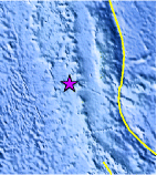
Magnitude 5.4 - BONIN ISLANDS, JAPAN REGION
2009 May 01 12:57:09 UTC
Earthquake Details
| Magnitude | 5.4 |
|---|---|
| Date-Time |
|
| Location | 26.223°N, 140.547°E |
| Depth | 415 km (257.9 miles) |
| Region | BONIN ISLANDS, JAPAN REGION |
| Distances | 175 km (110 miles) NNW of Iwo-jima, Volcano Islands, Japan 190 km (120 miles) WSW of Chichi-shima, Bonin Islands, Japan 1050 km (650 miles) S of TOKYO, Japan |
| Location Uncertainty | horizontal +/- 6.9 km (4.3 miles); depth +/- 14.3 km (8.9 miles) |
| Parameters | NST= 67, Nph= 67, Dmin=>999 km, Rmss=0.87 sec, Gp= 32°, M-type=body wave magnitude (Mb), Version=7 |
| Source |
|
| Event ID | us2009gca4 |
- This event has been reviewed by a seismologist.
- Did you feel it? Report shaking and damage at your location. You can also view a map displaying accumulated data from your report and others.

Earthquake Maps


Scientific & Technical Information
 Historic Moment Tensor Solutions
- Preliminary Earthquake Report
- U.S. Geological Survey, National Earthquake Information Center:
World Data Center for Seismology, Denver
