
 Feeds & Data
Magnitude 3.5 - CENTRAL CALIFORNIA
2009 May 01 15:39:25 UTC
Earthquake Details
| Magnitude | 3.5 |
|---|---|
| Date-Time |
|
| Location | 35.025°N, 119.309°W |
| Depth | 16.7 km (10.4 miles) |
| Region | CENTRAL CALIFORNIA |
| Distances |
|
| Location Uncertainty | horizontal +/- 0.5 km (0.3 miles); depth +/- 1.1 km (0.7 miles) |
| Parameters | Nph= 75, Dmin=4 km, Rmss=0.47 sec, Gp= 29°, M-type=local magnitude (ML), Version=O |
| Source | |
| Event ID | ci10403545 |
- This event has been reviewed by a seismologist.
- Did you feel it? Report shaking and damage at your location. You can also view a map displaying accumulated data from your report and others.
Earthquake Maps

Earthquake Location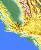
Location Maps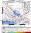
ShakeMap
PAGER
Population Exposure
Historical Seismicity
Seismic Hazard Map
Google Map
Google Earth KML
(Requires Google Earth)- Did you feel it? Report shaking and damage at your location. You can also view a map displaying accumulated data from your report and others.

