National Park Service LogoU.S. Department of the InteriorNational Park ServiceNational Park Service
National Park Service:  U.S. Department of the InteriorNational Park Service Arrowhead
Gila Cliff Dwellings National Monumenttesty
view map
text size:largestlargernormal
printer friendly
Gila Cliff Dwellings National Monument
Natural Features & Ecosystems
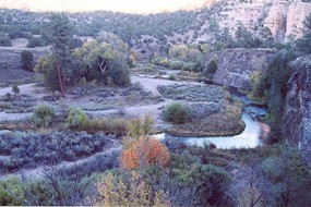
A photo of the winding headwaters of the Gila River north of the Forks Campground
NPS Photo by Barry Nielsen
A view of the headwaters of the Gila River north of the Forks campground.

Within a few miles of the cliff dwellings, elevations range from around 5,700 to 7,300 feet above sea level. In the immediate vicinity of the cliff dwellings, elevations range from 5,700 to about 6,000 feet. The terrain is rugged, with steep-sided canyons cut by shallow rivers; forested with ponderosa pine, Gambel's oak, Douglas fir, New Mexico juniper, pinon pine, and alligator juniper (among others); and usually dry. There are numerous caves in the area. There are several hot springs in the Gila National Forest and within hiking distance of the Visitor Center (there is also a privately-owned hot spring in the nearby community of Gila Hot Springs). Temperatures usually range from hot to very hot. The Visitor Center is located near the junction of the west and middle forks of the Gila River.


Aerial photo of dunes  

Did You Know?
The white sands dune field is an active dune field. The dunes move from west to east as much as thirty feet per year.

Last Updated: July 25, 2006 at 00:23 EST