
|
projects > coastal gradients of flow, salinity and nutrients
Coastal Gradients of Flow, Salinity and Nutrients
Summary
|
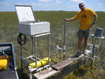
| The objective of this project is to operate and maintain ten hydrologic and water quality DCP's in the coastal and fresh water marsh environments of the Everglades in order to support a larger integrated monitoring network studying CERP restoration changes. |
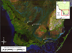
Hydrologic and water quality information from this network will be made available for the development and calibration of hydrodynamic and water quality models of the Everglades, Florida Bay, and adjacent marine systems, and will supply physical data to help evaluate impacts from the Comprehensive Everglades Restoration Plan (CERP). The network of data collection platforms (DCP's) collect information at points of interest along transects that represent major flow paths from the Everglades wetlands to the southern estuaries. The information collected on flow, salinity, temperature, ground water - surface water interactions, and nutrient flux will be provided annually within a USGS data report.
Scope of Work
Data
Metadata
Publications
Abstracts
- A comparison of rated discharge at Jewfish Creek using a 0.5 MHz and a 1.5 MHz Argonaut-SL using different sampling volumes (from the National Surface Water Conference and Hydroacoustics Workshop, April 2007)
- Estimates of Nutrient Loads at West Highway Creek in Northeastern Florida Bay (from the 2005 Florida Bay and Adjacent Marine Systems Science Conference)
- Northeastern Florida Bay Estuarine Creek Response During the 2004-05 Hurricane Seasons (from the GEER Conference, June 2006)
- Nutrient loading at Card Sound Canal - A tidally driven canal that experiences highly stratified, bidirectional flow conditions (from the November 2007 USGS National Water Quality Workshop)
- Nutrient Loading in the Coastal Creeks of Northeastern Florida Bay (from the Florida Bay and Adjacent Marine Systems Science Conference, December 2008)
- Nutrients Inputs along Coastal Transects within Everglades National Park, Florida (from the 2004 First National Conference on Ecosystem Restoration)
- Quantity, Timing, and Distribution of Freshwater Flows into Northeastern Florida Bay, 1996-2007 (from the Florida Bay and Adjacent Marine Systems Science Conference, December 2008)
- Temporal and Spatial Salinity Patterns in Joe Bay, Everglades National Park (from the GEER Conference, July 2008. This is a 3.5MB PDF and requires the FREE Adobe Acrobat Reader®)
- Using an Integrated Hydrologic Monitoring Network as a Tool to Analyze Everglades Ecosystem Response during CERP Implementation (from the 2004 First National Conference on Ecosystem Restoration)
- Using Hydrologic Monitoring as a Tool for Synthesis of the Greater Everglades and Southern Estuaries Modules of the Monitoring and Assessment Plan (from the GEER Conference, July 2008. This is a 3.5MB PDF and requires the FREE Adobe Acrobat Reader®)
Circulars
Fact Sheets
Maps
Posters
Presentations
Reports
Photos
|

 South Florida Coastal Real-Time Ground Water Stations
 South Florida Coastal Real-Time Surface Water Stations