
Hydrologic Monitoring of Volcanoes
Rivers route lahars and deliver sediment
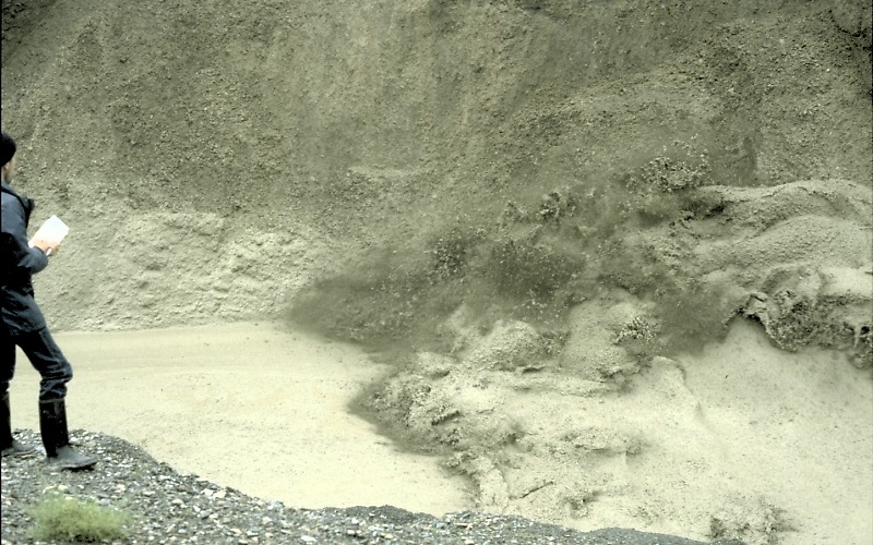
Photograph by K. Scott on June 24, 1990
When water combines with loose rocks and sediment in river valleys to form a flood or lahar, large areas downstream from a volcano can be buried with water and sediment several meters thick. Scientists monitoring an active volcano face the critical challenge of detecting a potentially dangerous lahar in real time so that a warning can be issued by public officials to people downstream.
An even more difficult and less obvious challenge for scientists, however, comes in the weeks and years after an eruption that significantly alters a volcano's watersheds--monitoring the long-term threat of sediment transport and increased flooding. For example, annual sediment yields following the explosive 1980 eruption of Mount St. Helens were as much as 500 times greater than typical background level. After 20 years, the average annual suspended-sediment yield in the Toutle River downstream from the 1980 landslide deposit was still 100 times above typical background level.
Why is this a potential problem? Such high sediment yields often cause river channels leading away from an active volcano to gradually fill with new, loose sediment. As such channels partially fill with sediment, their capacity to convey water within their banks is reduced, which commonly results in more frequent flooding during periods of intense rainfall. The experience at Mount St. Helens, and more recently with 1991 eruption of Mount Pinatubo in the Philippines, shows that effective mitigation measures must remain functional for decades following a major volcanic disturbance in order to reduce the likelihood of flooding.
Why does volcanic activity often lead to high rates of erosion and sedimentation?

Mount St. Helens 29 September 1980
Explosive eruptions that destroy vegetation and deposit volcanic rocks and ash over wide areas create conditions that (1) promote increased rates of surface runoff during rainstorms; and (2) dramatically increase the availability of loose debris that can be eroded and transported into river valleys. The destruction of vegetation combined with deposition of tephra on hill slopes reduces the amount of water that normally soaks into the ground or is transpired by plants. The increased overland flow of water erodes rock debris from hill slopes and carries it into river valleys. There, sediment can accumulate and can alter the hydraulic characteristics of the river channel.

Mount St. Helens 30 September 1981
The net effect of such changes to watersheds is that post-eruption stream velocities and peak discharges during rainstorms are temporarily much higher than during pre-eruption conditions. Streams typically respond more quickly to a given amount of rainfall and produce higher flows as rainfall is quickly flushed through a watershed.
Detecting lahars in real time

Scientists installing lahar-detection system, Mount Pinatubo, Philippines Installing system, Mount Pinatubo, Philippines Detection of lahars and other debris flows close to their sources provides an opportunity for timely warnings to people in downstream areas if adequate communication systems exist. USGS scientists have developed an inexpensive, durable, portable, and easily installed system to detect and continuously monitor the arrival and passage of debris flows and floods in river valleys draining active volcanoes. This system has the potential to save many lives from one of the most dangerous hazards posed to people who choose to live along rivers leading away from an active volcano. Details.
Measuring sediment on the move

Gray sediment-laden Toutle River, Mount St. Helens, Washington Sediment-laden Toutle River, Mount St. Helens Keeping track of how much sediment is carried downstream from volcanoes and deposited in river channels near farmland and communities is a major goal of a hydrologic monitoring effort. Most sediment is transported from volcanically-disturbed watersheds during periods of heavy rain. Scientists use stream-gaging instruments to measure the volumes of both water and sediment carried by rivers. Details.
Surveying river channels

Surveying deep channel eroded after 1980 eruption of Mount St. Helens Surveying eroded channel, Mount St. Helens New volcanic deposits consisting of loose, fragmented rocks are no match for the erosive power of running water, which can quickly carve wide and deep channels. In order to keep track of the erosion and corresponding sedimentation downstream, scientists make regular surveys across affected river valleys. Details.
Other hydrologic-monitoring methods and information
- Hydrothermal discharge in the western United States; provides data from 24 sites in the Yellowstone region, the northern Oregon Cascades, Lassen Volcanic National Park and vicinity, and Long Valley, California.
- Hydrologic studies in Long Valley Caldera, California.
- Water-resources data for U.S., including surface water, ground water, and water quality.
