
 Feeds & Data
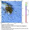
Magnitude 5.0 - ISLAND OF HAWAII, HAWAII
2009 April 14 22:44:45 UTC
Earthquake Details
| Magnitude | 5.0 |
|---|---|
| Date-Time |
|
| Location | 19.328°N, 155.210°W |
| Depth | 9.9 km (6.2 miles) |
| Region | ISLAND OF HAWAII, HAWAII |
| Distances |
|
| Location Uncertainty | horizontal +/- 0.5 km (0.3 miles); depth +/- 0.4 km (0.2 miles) |
| Parameters | Nph= 44, Dmin=5 km, Rmss=0.11 sec, Gp= 72°, M-type=local magnitude (ML), Version=1 |
| Source | |
| Event ID | hv00033612 |
- This event has been reviewed by a seismologist.
- Did you feel it? Report shaking and damage at your location. You can also view a map displaying accumulated data from your report and others.
Earthquake Summary


 Tsunami Information
- NOAA West Coast & Alaska Tsunami Warning Center
- NOAA Pacific Tsunami Warning Center
- Tsunami Information Links
The earthquake locations and magnitudes cited in these NOAA tsunami bulletins are very preliminary and may be superceded by USGS locations and magnitudes computed using more extensive data sets.
Earthquake Maps


Scientific & Technical Information
 Historic Moment Tensor Solutions
- Preliminary Earthquake Report
- U.S. Geological Survey, Hawaiian Volcano Observatory
Hawaii National Park, Hawaii
