Water Data
Monthly Water Conditions Report

April 2009: USGS Maryland-Delaware-DC Monthly Water Conditions Summary
Water Conditions Archives are available here.
Surface Water
NOTE: The term surface water includes the rivers, streams, ponds, and lakes of Maryland, Delaware, and D.C. Data about these resources is available in either real-time or monthly.
Real-Time
Real-Time Streamflow Levels

Hold down the Shift key and click on Reload or Refresh
to make sure you have the most recent image or table.
Monthly Data

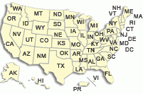
Current streamflow information maps are listed by county with 5 year information. Click the map below for more information. This information is based on readings from streamflow gages in the MD-DE-DC Water Science Center.
Freshwater Use and Withdrawals
During 2000, about 1,500 million gallons per day (Mgal/d) of freshwater was withdrawn from surface-water and ground-water sources in Maryland for a variety of uses including public-supply distribution (PS), commercial (CO), self-supplied domestic (DO), industrial (IN), mining (MI), thermoelectric power generation (TE), livestock watering (LV), aquaculture (AQ), and irrigation (IR). Click here for more information.
Flood Watch
|

Ground Water
Real Time
Real-Time Ground-Water Wells

Click the sites to view real-time data.
Monthly

Current ground-water information maps are listed by county, categorized by water table or confined aquifer, with 5 year information. This information is based on monthly readings from selected wells in the MD-DE-DC Water Science Center.
View Water-Table Wells or Confined Aquifer Wells..
Chesapeake Bay
Click for the monthly estimated streamflow entering Chesapeake Bay.
More information about USGS activities concerning the Chesapeake Bay can be found at the USGS Chesapeake Bay studies homepage.
Historical Water Data
National Water Conditions
Maps and animations of monthly streamflows
Surface-Water Data Retrieval (Daily streamflow and peak flows):
| Maryland | Delaware | ||
| DC | Virginia |
River Input Monitoring (Fall Line) stations
- Maryland - Susquehanna, Choptank, Patuxent, Potomac
- Virginia - Rappahannock, James, Pomunkey, Mattaponi, Appomattox
Weather and Climate Information
|
|
|
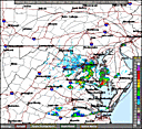
Weather and Climate Information Climatological data, weather forecasts, and live satellite imagery for the Maryland, Delaware, and the District of Columbia region from a variety of public and private resources. |
Left: Live Short Range Base Reflectivity from NWS in Sterling, VA |
Water Tools
CFS Calculator (Link opens a new window)
Convert values from cfs (cubic feet per second)
- Real-Time Streamflow Regional Quick-Navigation
This feature allows the user to navigate through each real-time station in numerical sequence (Maryland and Delaware)
- Click-through Graph Navigation
This feature allows the user to click through each real-time station, viewing only the latest streamflow charts (Maryland and Delaware)
- Frequently Asked Questions

- Water Watch
- Click to see the latest image from our Webcam at the Conowingo Dam!
- Related Information
- For an explanation of stream gaging, see:
- U.S. Geological Survey Circular 1123
Stream-Gaging Program of the U.S. Geological Survey
by K. L. Wahl, W. O. Thomas, Jr., and R. M. Hirsch. - PowerPoint Presentation: Data collection at U.S. Geological Survey Streamgages
HTML Format | PowerPoint File [13.4 mb]
- U.S. Geological Survey Circular 1123