Featured Projects
New York Water Quality Network
The New York District of the U.S. Geological Survey operates a water quality network throughout the New York City Watershed funded by New York City Department of Environmental Protection. The purpose of the network is to provide surface water stream flow and water quality data for selected streams throughout the Catskill Mountains within the New York City Watershed..... Find out more
What's in that Water? USGS Releases First Nationwide Look At Pharmaceuticals, Hormones And Other Organic Contaminants In U.S. Streams
Recent decades have brought increasing concerns for potential contamination of water resources that could result inadvertently during production, use, and disposal of the numerous chemicals offering improvements in industry, agriculture, medical treatment, and even common household conveniences. Increasing knowledge of the environmental occurrence or toxicological...Find out more
...Continued
Effects of recreational flow releases on natural resources of the Indian and Hudson Rivers
The New York State Department of Environmental Conservation (NYSDEC) is developing a unit management plan/environmental impact statement (UMP/EIS) for the Hudson Gorge Primitive Area, an area of Forest Preserve land encompassing a scenic stretch of the Hudson River in the Adirondack Park......Find out more
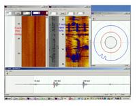
Borehole Geophysics
Borehole geophysics is the science of recording and analyzing measurements of physical properties made in wells or test holes. Probes that measure different properties are lowered into the borehole to collect continuous or.....Find out more
Recent Publications
- Heisig, P.M., 2009, Nutrients, dissolved organic carbon, color, and disinfection byproducts in base flow and stormflow in streams of the Croton watershed, Westchester and Putnam Counties, New York, 2000–02: U.S. Geological Survey Open-File Report 2009–1054, 105 p., online only.
- Monti, J. Jr., and Busciolano, R.J., 2009, Water-Table and Potentiometric-Surface Altitudes in the Upper Glacial, Magothy, and Lloyd Aquifers beneath Long Island, New York, March-April 2006: U.S. Geological Survey Scientific Investigations Map 3066, 4 sheets
- Benotti, M.J., 2008, Inventory of data sources used for watershed condition assessments of Fire Island National Seashore, Gateway National Recreation Area, and Sagamore Hill National Historic Site, New York and New Jersey: U.S. Geological Survey Open-File Report 2008–1298, 11 p., online only.
- Coon, W.F., 2008, Hydrologic Evidence of Climate Change in Monroe County, New York: U.S. Geological Survey Open-File Report 2008–1199, 12 p.
- Ernst, A.G., Baldigo, B.P., Schuler, G.E., Apse, C.D., Carter, J.L., and Lester, G.T., 2008, Effects of habitat characteristics and water quality on macroinvertebrate communities along the Neversink River in southeastern New York, 1991–2001: U.S. Geological Survey Scientific Investigations Report 2008–5024, 15 p.
|
|
|