
|
|
projects > salinity and turbidity patterns within estero bay aquatic preserve, lee county, florida
Salinity and Turbidity Patterns within Estero Bay Aquatic Preserve, Lee County, Florida
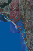
Estero Bay is a shallow estuary, across which salinity gradients from freshwater to saltwater occur over short land-sea distances. Such gradient compressions can result in a highly variable salinity environment and affect a diverse range of estuarine flora and fauna when even a small change in watershed runoff occurs. Rapid development within the bay's watershed has a changing effect on the amount, timing, and quality of runoff into the bay. Currently there is no information available to assess the effect that these alterations of runoff may have on the bay and its biota, nor to define watershed runoff and loading limits that provide desirable ranges in salinity and water quality at historical, current, and potential locations for seagrass, oysters, and other species of concern. To manage and preserve the Estero Bay ecosystem, it is necessary to: (1) understand the salinity patterns of the bay in relation to freshwater inflow and water exchange with the Gulf of Mexico; (2) describe the mixing and freshwater residence times within the bay; and (3) study the effects on light penetration from increased Total Suspended-Solids (TSS) load and re-suspension. Results from this study will facilitate management decisions geared toward defining flow and sediment loading limits that provide desirable ranges in salinity and water quality by providing necessary hydrological information. To carry out the objectives of the study, a network of monitoring stations will be established and will include: (1) the monitoring of flow, water level, salinity, temperature, Acoustic Backscatter Strength (ABS), and turbidity near the mouth of three of four tributaries flowing into Estero Bay; (2) monitoring of water level, salinity, temperature, turbidity, wind speed and direction, and barometric pressure at one location inside the bay; (3) monitoring of water level, flow, salinity, temperature, and ABS at three of four tidal exchange points with the Gulf of Mexico along the barrier islands; (4) monitoring of water level (depth), salinity and temperature at one open-water location in the Gulf of Mexico. ProposalsData
Metadata
|
U.S. Department of the Interior, U.S. Geological Survey
This page is: http://sofia.usgs.gov/projects/index.php?project_url=ebap
Comments and suggestions? Contact: Heather Henkel - Webmaster
Script last updated: 04 February 2009 @ 10:18 AM by BJM. Record creator: BJM. Record last updated by: TJE.