U.S. Geological Survey Fact Sheet 132-98
Online Version 1.0
U.S. Geological Survey
Fact Sheet 132-98
Online Version 1.0
| Although known for quiet eruptions of lava that rarely endanger lives, Kilauea Volcano on the Island of Hawai'i has also produced devastating and deadly explosive eruptions in the past. Because such eruptions are sure to occur again, U.S. Geological Survey (USGS) scientists are studying deposits from Kilauea's past explosive eruptions to better understand what caused them and to identify communities at risk from such eruptions in the future. |
The late 1780's were years of great strife on the Island of Hawai'i. Kamehameha, who later became the first king of the Hawaiian Islands, was at war with his rival Keoua. After one of several indecisive battles, probably in 1790, the balance was suddenly tipped in favor of Kamehameha when a natural disaster struck. As a large group of Keoua's warriors traveling with their families passed the crater of Kilauea Volcano, there was a sudden explosive eruption of searingly hot ash and gas. At least 80 and perhaps hundreds of people were killed in the deadliest historical eruption to occur in what is now the United States.
|
|
|
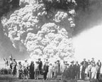
| About the year 1790 and in 1924, deadly explosive eruptions occurred at Kilauea Volcano, Hawai'i. Similar but much larger explosive eruptions devastated the volcano's summit area several times in the past few thousand years. In this photograph from 1973, steaming Halema'uma'u Crater, the site of the 1924 explosive eruption, lies within the larger volcanic depression (caldera) at Kilauea's summit. The U.S. Geological Survey's Hawaiian Volcano Observatory (lower center) perches on the caldera's northwest rim. Inset (courtesy of the Bishop Museum) shows tourists posing at a safe distance during the 1924 eruption. | |
Since 1790, only one much smaller explosive eruption has occurred in Hawai'i. During 18 days in May 1924, hundreds of steam explosions from Kilauea hurled mud, debris, and hot rocks weighing as much as 8 tons (7,000 kg) as far as two-thirds of a mile (1 km) from the center of Halema'uma'u the current crater within the larger volcanic depression (caldera) at Kilauea's summit. Columns of volcanic ash and dust rose more than 2 miles (3 km) into the air, at times turning day into night at the town of Pahala, nearly 20 miles (30 km) downwind. Fortunately, only one person was killed during this eruption, a photographer who ventured too close and was struck by falling rocks and hot mud.
|
Kilauea's
Explosive Eruptions can Produce Significant Ash Deposits
|
|
|
|
|
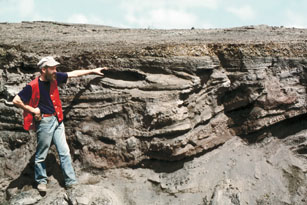
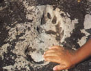
| The series of eruptions that produced the Keanakako'i Ash (top photo above being examined by a U.S. Geological Survey scientist) devastated an area of at least 75 square mile s (190 km 2). In about 1790, one of these eruptions struck a large party of Hawaiian warriors, killing at least 80 people in the deadliest historical eruption to occur in what is now the United States. Smaller photo above (courtesy National Park Service) shows one of hundreds of footprints, possibly made by the warriors, preserved in the Keanakako'i Ash. | |
|
|
|
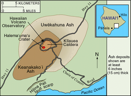
| At least two explosive eruptions between 2,700 and 2,000 years ago produced the Uwekahuna Ash, devastating an area almost two-thirds as large as the 230-square-mile (590-km 2) "blast zone" of the May 18, 1980, eruption of Mount St. Helens, Washington. Even older ash deposits are visible along the Hilina Pali fault scarp. | |
Explosive eruptions do not generally come to mind when people think of Hawai'i's volcanoes. Their eruptions are typically characterized by the relatively quiet outflow of very fluid lava and by sometimes spectacular lava fountains. Hawai'i's volcanoes have therefore become the textbook example of nonexplosive volcanism, and the term "Hawaiian type" is used to refer to such eruptions. Eruptions at Kilauea can often be observed safely at close range. For this reason, in 1912, volcanologist Thomas Jaggar established the Hawaiian Volcano Observatory (HVO), now operated by the U.S. Geological Survey (USGS) at the top of Uwekahuna Bluff near Kilauea's summit. Jaggar even called Kilauea "the safest volcano on Earth" because of its typically gentle activity.
Scientists now know that Kilauea in the past has produced numerous explosive eruptions, many dwarfing even the one that occurred about 1790. Although explosive eruptions at Kilauea are infrequent, deposits of ash discovered by USGS and other scientists document that they actually occur about as often as explosive eruptions from volcanoes in the Cascade Range of the Pacific Northwest, which includes Mount St. Helens, Washington.
| WHAT CAUSES EXPLOSIVE ERUPTIONS AT KILAUEA? |
|
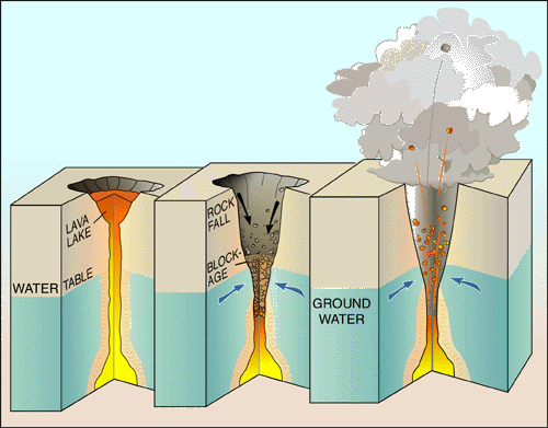
| Explosive eruptions at Kilauea are thought to be caused when water comes into contact with hot or molten rock (magma) and flashes into steam. In 1924, this happened after the level of the lava lake in Halema'uma'u Crater dropped below the water table. The walls of the crater then collapsed and blocked the opening down which the lava had drained, allowing steam pressure to build up and cause violent explosions. |
|
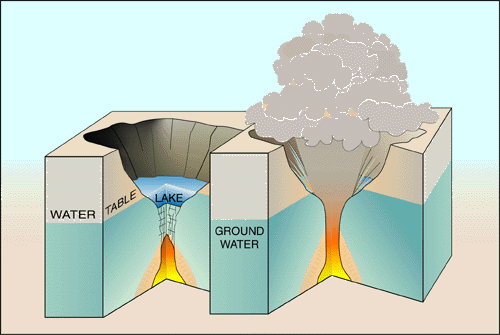
| Many of Kilauea's pre-1924 explosive eruptions that produced significant ash deposits probably happened when the volcano's summit crater was so deep that its floor was below the water table, letting ground water seep in to form a lake. Whenever magma erupted into the lake water, violent explosions of steam and volcanic gases resulted, fragmenting the magma into tiny ash particles and driving fast-moving, extremely hot ash-laden steam clouds (pyroclastic surges) out of the crater. |
At least nine layers of volcanic ash, the oldest of which are tens of thousands of years old, are exposed along cliffs in the Hilina fault system, 6 to 8 miles (10 to 13 km) south of Kilauea's summit. Most of these layers are at least a few feet thick, and some are several tens of feet thick. The oldest deposits from Kilauea's explosive eruptions that are still well enough preserved to be mapped over a wide area can be seen at the base of Uwekahuna Bluff. Known as the Uwekahuna Ash, these deposits represent at least two eruptions that occurred between 2,700 and 2,000 years ago. They are more voluminous and widespread than the younger deposits (Keanakako'i Ash) from a series of explosive eruptions at Kilauea that ended about 200 years ago and included the eruption that decimated Keoua's army. The Keanakako'i eruptions deposited more than a 100 million cubic yards (75,000,000 m3) of ash, which today still blankets most of Kilauea's summit and is in places more than 35 feet (10 m) thick.
Recent work by HVO and Smithsonian Institution scientists has discovered evidence of an explosive eruption that occurred on Kilauea's eastern flank approximately 1,100 years ago, about 500 years after Polynesians first settled in Hawai'i. Evidence has also been found of explosive eruptions that may have happened about 600 years ago, and ash deposits from still-younger eruptions have been found covering sites on Kilauea used by ancient Hawaiians. How these recently discovered eruptions affected ancient Hawaiians has yet to be determined.
Explosive eruptions at Kilauea are thought to be caused when water comes into contact with hot rock or magma and flashes into steam. In 1924, this happened after the lava lake in Halema'uma'u Crater sank hundreds of feet below the crater's rim over a period of a month, draining out of sight by late February of that year. Two months later, Halema'uma'u's floor began to sink. This weakened the crater's walls, causing rock falls that enlarged the crater. By May 10th, large parts of the walls had collapsed, filling and blocking the opening of the conduit down which the lava had drained. Ground water seeping into the conduit flashed into steam when it encountered hot rock and rapidly built up pressure beneath the blockage. The steam then escaped violently (as in a boiler explosion), blasting away the blockage and scattering rocks and dust into the air. During the next 17 days, this cycle of collapse, blockage, and explosion was repeated hundreds of times.
Many of Kilauea's pre-1924 explosive eruptions that produced significant ash deposits probably happened when the volcano's summit crater was so deep that its floor was below the water table, letting ground water seep in to form a lake. Whenever magma erupted into the lake water, violent explosions of steam and volcanic gases resulted. These explosions fragmented the magma into tiny ash particles and drove ash-laden steam clouds (pyroclastic surges), like those that killed Keoua's warriors, out of the crater at speeds as great as 100 miles an hour (160 km/h).
Because the water table at Kilauea currently lies about 1,700 feet (520 m) below the rim of Halema'uma'u, there is little chance of imminent explosive eruptions. However, since the early 1820's, the floor of Kilauea's summit crater has dropped to within 300 feet (90 m) of the water table at least three times, and any future subsidence of this magnitude would be cause for concern. Future explosive eruptions of Kilauea could endanger the lives of the thousands of people who live, work, or spend time as visitors near the volcano.
The explosive history of Kilauea continues to be revealed through investigations by USGS and other scientists. Knowledge gained from these studies is being used at HVO to identify communities at risk from eruptions of Hawai'i's active volcanoes. These volcanoes are being closely monitored by HVO scientists so that they can alert the public and local government officials to impending eruptions. The work of HVO is part of the USGS Volcano Hazard Program's ongoing efforts to help protect people's lives and property from volcano hazards in all of the volcanic regions of the United States, including Hawai'i, Alaska, Wyoming, California, and the Pacific Northwest.
Larry G. Mastin, Robert L. Christiansen, Donald A. Swanson, Peter H. Stauffer, and James W. Hendley II
Graphics by Susan Mayfield and Sara Boore
For more
information or paper copies of this fact sheet contact:
Hawaiian Volcano Observatory (808) 967-7328
P.O. Box 51
Hawai'i Volcanoes National Park, HI 96718
Also, visit the Hawaiian Volcano Observatory on the Web.
COOPERATING
ORGANIZATIONS
Center for the Study of Active Volcanoes, University of Hawai'i at Hilo
Department of Defense, Pacific Disaster Center
Hawai'i County Civil Defense
Hawai'i Office of State Planning
Hawai'i State Civil Defense
National Park Service
National Oceanic and Atmospheric Administration, Pacific
Tsunami Warning Center
Smithsonian Institution
Related Fact Sheets
Volcanic Air Pollution--A Hazard in Hawai'i (USGS Fact Sheet 169-97)
Living on Active Volcanoes--the Island of Hawai'i (USGS Fact Sheet 074-97)
See a list of other volcano-related fact sheets published by the U.S. Geological Survey
PDF version of this fact sheet
U.S. GEOLOGICAL SURVEY–REDUCING THE RISK FROM VOLCANO HAZARDS
Learn more about volcanoes and the hazards they pose at the USGS Volcano Hazards Program website
URL of this page: http://pubs.usgs.gov/fs/fs132-98/
Maintained by: Michael Diggles
Last modified: October 14, 2004 (mfd)