U.S. Geological Survey Fact Sheet 074-97
Online Version 1.1
U.S. Geological Survey
Fact Sheet 074-97
Online Version 1.1
| People on the Island of Hawai`i face many hazards that come with living on or near active volcanoes. These include lava flows, explosive eruptions, volcanic smog, damaging earthquakes, and tsunamis (giant seawaves). As the population of the island grows, the task of reducing the risk from volcano hazards becomes increasingly difficult. To help protect lives and property, U.S. Geological Survey (USGS) scientists at the Hawaiian Volcano Observatory closely monitor and study Hawai`i's volcanoes and issue timely warnings of hazardous activity. |
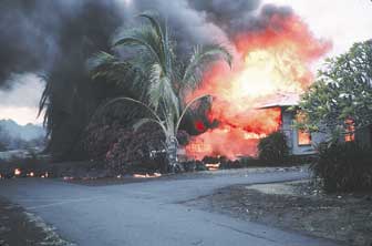
Late in the evening of June 1, 1950, after many residents of Ho`okena-mauka village on the west coast of the Island of Hawai`i had already gone to bed, Mauna Loa Volcano suddenly began to erupt. Hot, glowing lava poured from fissures and rushed down the southwest flank of the volcano. In only 3 hours, the swiftly flowing lava traveled 14 miles and entered the village. The darkness was lit by flames as the molten lava consumed several houses and the Post Office. By daybreak, lava flows had crossed the area's only road in two places, cutting off all escape routes. Fortunately, the residents of Ho`okena-mauka escaped unharmed, but for some it was a close call.
|
|
| In 1990, flows of lava from Kilauea Volcano on the Island of Hawai`i invaded Kalapana, a coastal community treasured for its historic sites and black-sand beaches. Although the residents were able to evacuate safely, their homes were incinerated, and by the end of that year all of Kalapana lay buried under 50 feet of lava. In the past 1,100 years, more than 90 percent of Kilauea 's surface has been covered by new lava flows. Ancient Hawaiian communities were able to easily relocate when threatened by lava flows, but modern communities, with their greater dependence on permanent structures, highways, and utilities, are more vulnerable. |
The Island of Hawai`i is composed of five volcanoes, two of which–Mauna Loa and Kilauea–have erupted repeatedly in this century. Another of these volcanoes, Hualalai, last erupted in 1801 and has the potential to erupt again within our lifetime. Most eruptions at Hawaiian volcanoes are not explosive and are characterized by the relatively quiet outflow of very fluid lava. These eruptions can still be deadly, because the lava may be erupted in huge volumes, and on steeper slopes fluid lava can rapidly travel many miles from its source.
|
|
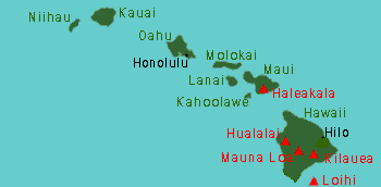
| The Hawaiian Islands are at the southeast end of a chain of volcanoes that began to form more than 70 million years ago. Each island is made of one or more volcanoes, which first erupted on the sea floor and emerged above the ocean's surface only after countless eruptions. Most of the volcanoes active in the past two centuries (red) are on the Island of Hawai`i, the youngest island in the chain. Haleakala Volcano, on the Island of Maui, also erupts every few centuries, most recently in 1790. Loihi, the newest volcano, is still 3,000 feet beneath the ocean's surface. |
Mauna Loa, the world's largest active volcano, last erupted in 1984. During that 3-week-long eruption, rivers of lava came within 4 miles of the outskirts of the coastal city of Hilo. Most of Mauna Loa's eruptions in the last 150 years began at eruption sites (vents) near the volcano's remote 13,677-foot-high summit. About half of these summit eruptions quickly developed into eruptions on the flanks of the volcano. Mauna Loa's flank eruptions usually occur along one of two zones of weakness, called rift zones, that extend partway down its northeast and southwest slopes. A few eruptions also have taken place from isolated vents on the volcano's northern slope.
Eruptions from Mauna Loa's northeast rift zone can send lava flows coursing toward distant Hilo. However, those on the southwest rift zone present the greater threat to life and property, because residential areas developed since the volcano's 1950 eruption lie immediately downslope of potential vents.
Kilauea Volcano, Mauna Loa's younger neighbor, tends to have long-lasting eruptions. Kilauea's ongoing eruption, which began in 1983, is already the volcano's most destructive in the past 100 years. From 1983 to 1991, lava flows repeatedly invaded communities on Kilauea's coastal south flank, burying 8 miles of highway and destroying 181 houses and a visitor center in Hawai`i Volcanoes National Park. Most lava flows erupted since 1992 have remained within the National Park, but Kilauea's geologic history indicates that future activity will again threaten residential areas on the volcano's south flank.
|
|
|
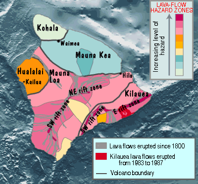
Lava flows are the volcano hazard most likely to seriously threaten people and property on the Island of Hawai`i. The U.S. Geological Survey (USGS) prepares and periodically revises maps of lava-flow hazard zones for the island. These zones are based on the locations of probable eruption sites, likely paths of lava flows, and how frequently lava has covered an area in the geologic past. |
Although Kilauea's eruptions tend to last longer, Mauna Loa poses a greater hazard because of the enormous volumes of lava it produces and the greater steepness of its slopes. Mauna Loa's 1984 eruption paved 16 square miles of land with lava in just 3 weeks, whereas the ongoing eruption of Kilauea that began in 1983 took 3 years to cover a comparable area.
Although explosive eruptions occur infrequently at Hawaiian volcanoes, they can be devastating. In about 1790, Kilauea exploded in the deadliest eruption known to have occurred in what is now the United States. At least 80 people were killed when a group of Hawaiian warriors and their families was overwhelmed by an extremely fast-moving flow of hot gas and ash (pyroclastic surge) near Kilauea's summit. Thick deposits of volcanic ash on the Island of Hawai`i indicate that much more powerful explosive eruptions have occurred in prehistoric times.
Sulfur dioxide gas, continuously emitted during Kilauea's current long-lived eruption, has resulted in persistent volcanic smog ("vog") in downwind areas. Vog, as well as acid rain, forms when sulfur dioxide gas reacts with atmospheric moisture. Vog aggravates respiratory problems, and acid rain damages crops and corrodes metal. On the Island of Hawai`i, the drinking water of many homes with rain-water catchment systems has been contaminated by lead leached by acid rain from roofing and plumbing materials.
Earthquakes are another hazard associated with active volcanoes, and the Island of Hawai`i experiences thousands each year. Most of these are too small to feel, but about once a decade a large quake shakes the entire island and causes widespread damage. Before and during an eruption, many small earthquakes occur as molten rock (magma) forces its way through the upper parts of a volcano's interior, and such quakes often provide early warnings of changes in eruptive activity. Deeper within a volcano, stronger earthquakes can be triggered by the stresses exerted by rising magma.
The most powerful earthquake to strike the Island of Hawai`i in the past century was the magnitude 7.2 shock of November 1975. This quake occurred beneath Kilauea's south flank and generated huge ocean waves (tsunamis) that caused two deaths and substantial damage along the nearby coast. Such locally generated tsunamis are extremely dangerous, because there is no time to warn the public before the waves strike. A strong earthquake should therefore be regarded by people near the coast as a signal to leave immediately for higher ground! (See Surviving A Tsunami—Lessons from Chile, Hawaii, and Japan, USGS Circular 1187)
|
|
| The USGS Hawaiian Volcano Observatory (HVO) operates a network of seismometers to monitor the thousands of earthquakes that the Island of Hawai`i experiences each year. Most of these are too small to feel, but about once a decade a large quake shakes the entire island and causes widespread damage. To help protect people and property in the large earthquakes that are certain to occur in the future, HVO scientists are working with State and local officials to ensure that building codes used on Hawai`i accurately reflect the seismic hazard. |
To better understand Hawaiian volcanoes and the hazards they pose, the Hawaiian Volcano Observatory (HVO) was established in 1912 at the summit of Kilauea. The observatory, operated continuously by the U.S. Geological Survey (USGS) since 1947, studies current geologic activity at Hawaii's volcanoes, as well as evidence of past eruptions, earthquakes, and other volcano hazards. HVO scientists use this information to provide timely warnings to local officials and the public, to assess long-term volcano hazards, and to make hazard-zone maps that help guide land-use planning decisions.
The progress of Kilauea's current eruption is being closely tracked by HVO scientists. The information they provide on projected lava-flow movements helps public safety officials determine when it is necessary to evacuate residents or close roads. On Mauna Loa, HVO instruments have detected swelling indicating that the volcano's magma reservoir has been refilling since its 1984 eruption. HVO scientists continue to monitor this swelling and are watching for signs of increased earthquake activity such as that which preceded the volcano's last two eruptions.
|
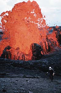
Spectacular lava fountains are a common feature of eruptions at Hawaiian volcanoes. This relatively small lava fountain from Kilauea Volcano was active in 1993. In the photo, a U.S. Geological Survey scientist from the Hawaiian Volcano Observatory has just collected a sample of the newly erupted lava for analysis. The chemical composition and other characteristics of such samples can indicate impending changes in a volcano's eruptive activity. |
By helping to educate residents, public officials, and visitors about volcano hazards on the Hawaiian Islands, USGS scientists at HVO are enabling people to lead safer lives in a setting where spectacular volcanic eruptions and damaging earthquakes occur. The work of HVO is part of the USGS Volcano Hazards Program's ongoing efforts to help protect people's lives and property in all of the volcanic regions of the United States, including Hawai`i, California, the Pacific Northwest, Wyoming, and Alaska.
Christina Heliker, Peter H. Stauffer, and James W. Hendley II
Graphics by Susan Mayfield and Sara Boore
Banner design by Bobbie Myers
Web design and layout by Carolyn Donlin
COOPERATING
ORGANIZATIONS
Center for the Study of Active Volcanoes,
University of Hawai`i at Hilo
Dept. of Defense Pacific Disaster Center
Hawai`i County Civil Defense
Hawai`i Office of State Planning
Hawai`i State Civil Defense
National Park Service
National Oceanic and Atmospheric Administration, Pacific Tsunami
Warning Center
Related Fact Sheets
What Are Volcano Hazards? (USGS Fact Sheet 002-97)
Volcanic Air Pollution—A Hazard in Hawai`i (USGS Fact Sheet 169-97)
Explosive Eruptions at Kilauea Volcano, Hawai`i? (USGS Fact Sheet 132-98)
See a list of other volcano-related fact sheets published by the U.S. Geological Survey
PDF version of this fact sheet
U.S. GEOLOGICAL SURVEY—REDUCING THE RISK FROM VOLCANO HAZARDS
Learn more about volcanoes and the hazards they pose at the USGS Volcano Hazards Program website