|
Environmental Sensitivity Index (ESI) Maps
ESI maps provide a concise summary of coastal resources that are at risk if an oil spill occurs nearby. Examples of at-risk resources include biological resources (such as birds and shellfish beds), sensitive shorelines (such as marshes and tidal flats), and human-use resources (such as public beaches and parks).
When an oil spill occurs, ESI maps can help responders meet one of the main response objectives: reducing the environmental consequences of the spill and the cleanup efforts. Additionally, ESI maps can be used by planners--before a spill happens--to identify vulnerable locations, establish protection priorities, and identify cleanup strategies.
 |
|
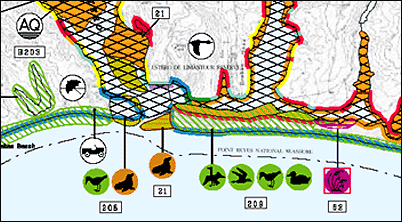
Shorelines on ESI maps are color-coded by sensitivity to oil. Symbols mark localized areas for biological and human-use resources.
|
Key Features of ESI Maps and Data
- Uses GIS techniques to integrate maps of a region with geographically-referenced biological resources, human-use resources, and ESI-classified shorelines that are ranked based on their sensitivity to oiling.
- Contains a summary view of ESI data on the back of the paper map, and GIS versions of the ESI data that can be used for more complex queries.
- Serves as a quick reference for oil spill responders and coastal zone managers.
- Available as a single map, or a regional collection of maps called an ESI atlas.
- Available in print and electronic formats (including several GIS formats) for most coastal regions of the U.S., as well as a few international locations.
ESI maps are created by NOAA OR&R researchers, working with colleagues in state government agencies, federal government agencies, and industry.
Key ESI Resources
- Get ESI Maps and Data Find out how to order or download ESI maps and data.
- Basics Learn the basics, including the types of information that are mapped.
- Exercises and Training Use these modules to practice using ESI maps and data.
- Toolkit Browse a collection of resources for ESI users.
- Availability See the regions that have been mapped and available formats.
- Formats Review the types of formats that are available for ESI maps and data.
- ESI Specialist Contact the ESI Specialist for more information.
For More Information
|
- ESI Fact Sheet Basic information and list of available atlases.
(Document format: PDF, size: 1.6 M)
|
- ESI Atlases: Sample Sample ESI atlas, which includes an ESI map with seasonality data; background information about shoreline habitat ranking and sensitive biological and human-use resources; a list of species included in the atlas; a description of shoreline habitat types; a map legend; and guidelines for interpreting ESI maps.
(Document format: PDF, size: 2.3 M)
|
|