| Home >> | Advanced Search >> |
|
|
|
Astronaut Photography of Earth - Display Record
ISS018-E-38182
Low-resolution Browse Image
(Most browse images are not color adjusted.)Images
Conditions for Use of Images >>Image Transformation Tutorial >> Saving, Color Adjusting, and Printing Images >>
Images to View on Your Computer Now
| File Name | File Size (bytes) | Width | Height | Annotated | Cropped | Purpose | Comments | |
|---|---|---|---|---|---|---|---|---|
| View | ISS018-E-38182.JPG | 80913 | 640 | 437 | No | No | ||
| View | ISS018-E-38182.JPG | 233955 | 540 | 357 | Yes | Yes | NASA's Earth Observatory web site |
Large Images to Request for Downloading
| File Name | File Size (bytes) | Width | Height | Annotated | Cropped | Purpose | Comments | |
|---|---|---|---|---|---|---|---|---|
| Request | ISS018-E-38182.JPG | 696625 | 1000 | 662 | No | Yes | NASA's Earth Observatory web site | |
| Request | ISS018-E-38182.JPG | 798967 | 3072 | 2098 | No | No |
Download a Keyhole Markup Language (KML) file for use in Google Earth.
Electronic Image Data
Camera Files >> No sound file available.Identification
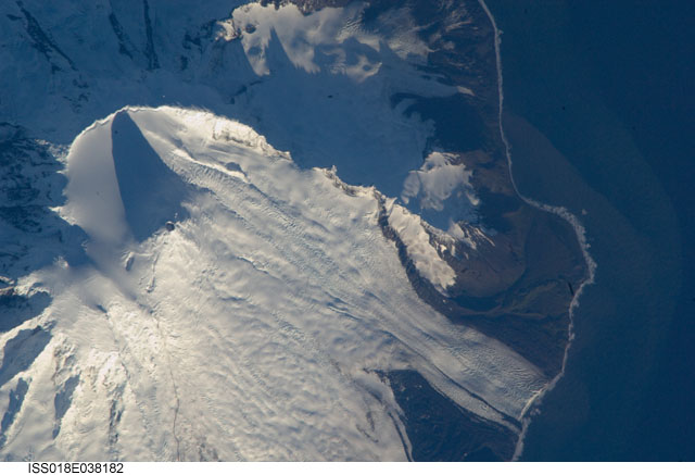
Mission: ISS018 Roll: E Frame: 38182 Mission ID on the Film or image: ISS018Country or Geographic Name: ANTARCTICA
Features: S.W. AREA OF HEARD I., MAWSON PEAK, FREMANTLE PEAK
Center Point Latitude: -53.1 Center Point Longitude: 73.5 (Negative numbers indicate south for latitude and west for longitude)
Stereo: (Yes indicates there is an adjacent picture of the same area)
ONC Map ID: JNC Map ID:
Camera
Camera Tilt: 36Camera Focal Length: 800mm
Camera: N2: Nikon D2Xs
Film: 4288E : 4288 x 2848 pixel CMOS sensor, RGBG imager color filter.
Quality
Film Exposure:Percentage of Cloud Cover: 10 (0-10)
Nadir
Date: 20090228 (YYYYMMDD)GMT Time: 125441 (HHMMSS)Nadir Point Latitude: -51.3, Longitude: 71.9 (Negative numbers indicate south for latitude and west for longitude)
Nadir to Photo Center Direction: Southeast
Sun Azimuth: 271 (Clockwise angle in degrees from north to the sun measured at the nadir point)
Spacecraft Altitude: 197 nautical miles (365 km)
Sun Elevation Angle: 11 (Angle in degrees between the horizon and the sun, measured at the nadir point)
Orbit Number: 2885
Captions
Mawson Peak, Heard IslandHeard Island is located in the southern Indian Ocean, approximately 1,550 kilometers (963 miles) north of Antarctica. The island is a visible part of the Kerguelen Plateau, a submerged feature on the seafloor. The plateau was formed when large amounts of volcanic rock erupted over a geologically short time period. (When large amounts of volcanic rock erupt beneath the ocean from processes other than seafloor spreading, geologists refer to them as large igneous provinces.) Most of Heard Island is formed from volcanic rocks associated with the Big Ben stratovolcano. The northeastern slopes of the volcano are visible in shadow at the lower right of this detailed astronaut photograph.
Recent volcanic activity at Heard Island has occurred at 2,745-meter (9,006-foot) Mawson Peak, which sits within a breached caldera on the southwestern side of the Big Ben Volcano. Calderas form when a magma chamber beneath a volcano empties and collapses. The shadow cast by Mawson Peak points directly to the crescent-shaped caldera rim. Detailed geologic study of Big Ben Volcano is complicated by the presence of several glaciers, including Gotley and Lied Glaciers on the southwestern slopes. This image, taken during Southern Hemisphere summer, also reveals non-glaciated volcanic rock (light to dark brown) on either side of Gotley Glacier.
Download Packaged File.
This option downloads the following items, packaged into a single file, if they are available:
- Browse image
- Cataloged information with captions
- Camera file
- Sound file
Server: 2 |
This service is provided by the International Space Station program. |
Recommended Citation: |
||

